
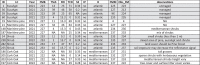
Table 4.
Random selection of areas extracted from the fieldwork database to show fuel model assignment in each of the main land cover types in the field. ID=Identifier of the area; LC=land cover; FMB=Fuel Model in the Basemap; TSLF=Time Since Last Fire (DATASET C); FRI=Fire Return Interval (DATASET C); TCD=Tree Cover Density (DATASET D); S2=Sentinel-2 (DATASET E); IP=Industrial Properties (DATASET G); H=Mediterranean/Atlantic classification (DATASET H); FMM= Fuel Model map; Obs_FM=Observed Fuel Model (DATASET F). A photo for each ID is shown in Fig. S3.
 |