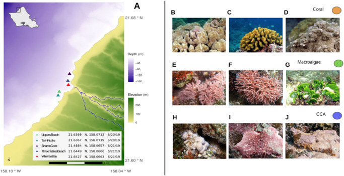
Fig. 2. Sampling locations and taxa.
a Map of sampling sites showing depth and elevation gradients within the study area. Bathymetry data courtesy of Hawaiʻi Mapping Research Group, SOEST, UH Mānoa and elevation data courtesy of the U.S.G.S. National Elevation Dataset. Site locations were collected by handheld GPS. The map was created using the R language for statistical programming (code available in the public GitHub repository associated with this manuscript). b–j Representative photos of benthic primary producers collected from Waimea Bay, Oʻahu. Scleractinian reef corals (b) Porites lobata, (c) Pocillopora meandrina, and (d) Montipora capitata; erect rhodophytes (e) Jania and (f) Galaxaura, and a calcifying chlorophyte (g) Halimeda; and crustose coralline algae (h) Hydrolithon, (i) Lithophyllum, and (j) Hydrolithon (PC: Keoki and Yuko Stender). For standardization in all of the analyses performed in this work, coral, macroalgae, and CCA samples were defined as orange, green, and blue, respectively. Collection permit: Hawaiʻi State Department of Land and Natural Resources Division of Aquatic Resources Special Activity Permit No. 2020-23. Representative photographs of benthic primary producers were obtained from https://www.marinelifephotography.com with authorization from Keoki Stender.

