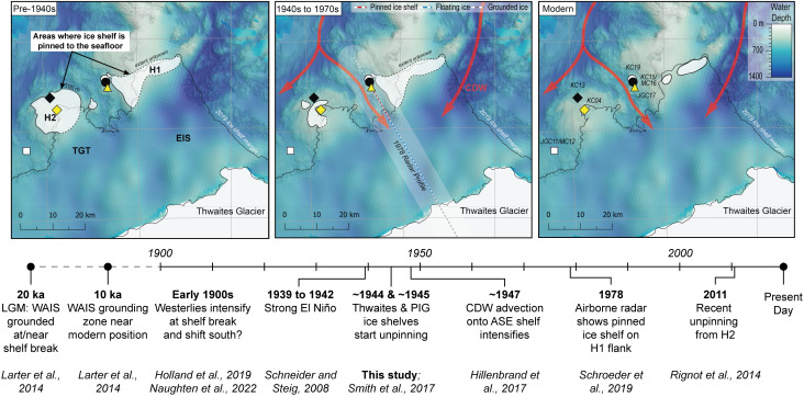
Fig. 6.
Unpinning of the Thwaites Glacier Tongue (TGT) and Eastern Ice Shelf (EIS) from seafloor highs, previously named H1 and H2, during the twentieth century (panels above) in the context of the long-term climate and glaciological history of the Amundsen Sea drainage sector of the WAIS (timeline below; ASE: Amundsen Sea Embayment; PIG: Pine Island Glacier) (10, 13, 16, 37, 50, 56–58). White polygons in each panel illustrate areas where Thwaites Glacier is grounded and where the ice shelf is pinned to seafloor highs. Note that the ice shelf is floating between the grounding zone and pinning points. The white polygon beneath the ‘Thwaites Glacier’ label indicates approximate modern grounded ice extent in the south (bottom of the maps). The earliest satellite-based grounding-zone locations are from the 1990s (33). The radar profile implies that the grounding zone (gray and white line in the Middle panel) was advanced only ~5 km north in 1978 (13). Reconstructions are based on seafloor bathymetry, core chronology, airborne radar surveys, and satellite data (10, 13, 15, 37, 50). Water depth and core site names are shown in the Right panel. The intensification of westerlies in the early 1900s is noted with a question mark because some climate models do not clearly support this trend over the past century (59).

