
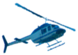
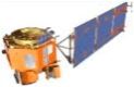
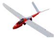
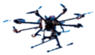
Table 1.
Comparative Analysis of distinct platforms for hyperspectral imaging [14].
| Specifications | Airplanes | Helicopters | Satellites | Fixed Wing UAV | Multi UAV |
|---|---|---|---|---|---|
| Example Image | 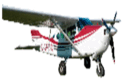 |
 |
 |
 |
 |
| Operational Altitudes | 1–20 km | 100 m- 2 km | 400–700 km | <150 m | <150 m |
| Spatial Coverage | ∼100 km2 | ∼10 km2 | 42 × 7.7 km | ∼5 km2 | ∼0.5 km2 |
| Spatial Resolution | 1–20 m | 1.1–1 m | 20–60 m | 1.1–0.5 m | 0.01–0.5 m |
| Temporal Resolution | Depends on operations of flights (Hours to Days) | ||||
| Flexibility | Medium (Limited by availability of aviation) | Low (Fixed repeating cycles) | High | ||
| Operational Complexity | Medium (Depending on the sensor operator) | Low (Data provided to users) | High (Software & Hardware of setup by users) | ||
| Applicable Scales | Regional landscape | Global landscape | Canopy landscape | ||
| Cost of Acquisition | High (requires aviation company to fly) | Low to Medium | High (for a large area) | ||
| Limiting Factors | Unfavorable flight speed | Weather | Flight regulations | ||