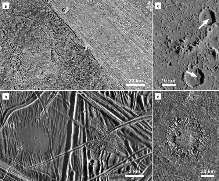
Fig. 3.
Examples of landforms created by the main four geological processes that shape the surfaces of the icy Galilean satellites. (a) Structural features in dark and bright terrains of Ganymede (Nicholson Regio and Harpagia Sulcus, respectively) are visible as linear zones of fractures. (image: NASA/JPL/DLR). (b) On Europa, a ∼3 km patch («puddle») of smooth, level terrain left of the image centre is interpreted as an area that has been flooded by an extruded liquid (water). Many tectonic fractures with different orientations and styles are crossing the entire scene (image: NASA/JPL/ASU). (c) Landslide deposits in craters on Callisto. The two landslides (arrows) are about 3 to 3.5 km long and are a result of mass wasting at the inner crater walls (image: NASA/JPL/ASU). (d) Dome crater Neith on Ganymede. The 45 km dome in the crater interior is surrounded by a concentric zone of rugged terrain, which represents a former central pit. The actual crater rim is barely visible and is located along the outer boundary of a relatively smooth, circular area. Neith is one example of a crater whose topography was strongly modified by post-impact relaxation or by the response of a weak substrate to a high-energy impact (image: NASA/JPL/DLR). North is up in all images

