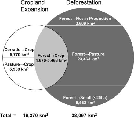
Fig. 4.
Relationship between cropland expansion and deforestation in Mato Grosso, Brazil, during 2001–2004. Estimates of forest conversion directly to cropland range from 4,670 (33) to 5,463 km2 (this study). Expansion of large-scale mechanized agriculture was estimated from annual land cover maps of Mato Grosso derived from MODIS-based phenology information; only transitions from forest, Cerrado, or pasture/grasslands to double-cropping systems are included in this estimate (33). Estimated cropland expansion from agricultural census data of total planted area is nearly two times the area derived from satellite data, because individual fields are counted separately for each crop rotation in the agricultural census.

