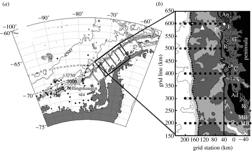
Figure 1.
(a) Palmer LTER study region along the WAP showing sampling grid (filled squares with labelled contoured bathymetry (750 m intervals) and climatological southern edge of Antarctic Circumpolar Current (ACC; dashed grey line). (b) The main sampling grid occupied each January since 1993 consists of stations (small squares 10 km apart) arranged in 10 onshore to offshore lines spaced 100 km apart, with line 000 to the south and 900 to the north along the peninsula (only lines 200–600 shown); stations proceed offshore from an arbitrary 0 line defining the peninsular coastline. Bathymetry shaded (white≥750 m, 750 m<light-grey≤450 m, dark-grey<450 m) and contoured (greater than or equal to 1500 m at 750 m intervals); white diamond, Palmer Station; white triangle, long-term sediment trap mooring; F, Faraday (Vernadsky) base; P, Palmer Deep region on shelf; Ro, Rothera Station; G and C, Grandidier Channel and Crystal Sound; MB, Marguerite Bay; An, R and Ad, Anvers, Renaud and Adelaide Islands, respectively; continental shelf break indicated by dashed bold line (slope to left); shelf-coastal subregions separated by solid bold line; and small white circles, various stations ‘inside’ the islands and channels with distinct hydrography influenced by glacial ice melt.

