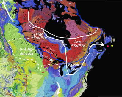
Fig. 1.
Bedrock map of central–eastern North America (16) showing major lithologies that influence river geochemistry. Colors are coded according to bedrock age: red shades are Precambrian, blue shades are Paleozoic, green shades are Mesozoic, and yellow is Cenozoic. We have identified those geochemical properties of bedrock types that produce distinctive signals in drainage basins. The western part of the Canadian Precambrian Shield has higher 87Sr/86Sr than the eastern Shield, Paleozoic sedimentary bedrock underlying the eastern Great Lakes includes Mg-rich dolomite, and Mesozoic sedimentary bedrock of the western Canadian Plains is enriched in U and Mg. Also shown is the outline (in blue) of the 12.5 calibrated kyr B.P. ice margin (26) and the southwestern margin of the Laurentide Ice Sheet at the start of the Younger Dryas (13 calibrated kyr B.P.) and near the end of the Younger Dryas (11.5 calibrated kyr B.P.) (26) (dashed black lines) [the age of these margins, however, is not constrained by dates (26)]. The solid white line is the pre-Younger Dryas drainage area of the St. Lawrence River with its northern margin controlled by the ice sheet divide (7). The dashed white line represents the additional area routed to the St. Lawrence River at the start of the Younger Dryas (7). White arrows indicate the freshwater drainage routes to the Arctic, the Gulf of Mexico, and the St. Lawrence River, and the blue arrow indicates the general location of the eastern outlet for glacial Lake Agassiz. Core locations in the outer St. Lawrence estuary are shown as a red dot (core 90031-047) and a yellow dot (core 90031-044).

