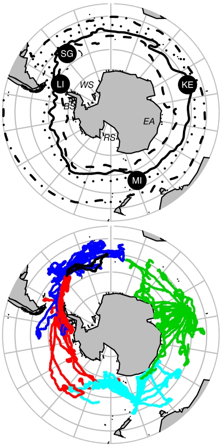
Fig. 1.
Orthographic view of the SO. (Upper) The four sites of instrument deployments are indicated by the filled black circles (SG, South Georgia; KE, Kerguelen Islands; MI, Macquarie Island; LI, Livingston Island), whereas the black lines represent mean locations of the major ACC fronts. From north to south, these include the Subtropical Front (dotted-dashed line) and SAF (dotted line) taken from Orsi et al. (36), followed by the PF (solid line) and SACCF (dashed line), taken from Moore and Abbott (51), the latter modified in the Scotia Sea region by data from Argo floats and CTD-SRDLs deployed on seals in this study (L.B., S.T., M.M., M.B., and M.A.F., unpublished work). The Weddell Sea (WS), East Antarctica (EA), Ross Sea (RS), and Bellingshausen Sea (BS) are also indicated. (Lower) The circumpolar movements of 85 southern elephant seals between January 2004 and April 2006. Colors represent tracks from South Georgia (dark blue), Kerguelen (green), Macquarie (light blue), and the South Shetlands, Antarctica (red). Note the contrast between seals in the Atlantic sector showing a preference for ACC waters compared with the rapid southerly migrations by most Kerguelen and Macquarie seals across ACC waters toward the continental margin of East Antarctica or into the Ross Sea. The longest track (326 days) is shown in black.

