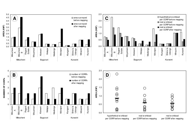
Figure 6.
Impact of technical mapping. Situation in each of the 12 neighbourhoods of the study area, directly before and three months after the preliminary sketch maps were formalized and corrected by using the technical mapping approach with aerial photographs. A. Total area in km2 surveyed by CORPs (*) before and after technical mapping. The latter is equal to 100% of the surface area of all 12 neighbourhoods. B. Number of CORPs before and after technical mapping. C and D. Average weekly workload per CORP in km2 (**) before and after technical mapping. "Hypothetical workload" assumes that the sketch maps had been correct and leaving no gaps within each neighbourhood from the beginning, and that the CORPs had surveyed all these areas even before the sketch maps were verified. "Real workload" only takes into account the area actually surveyed by CORPs. The circles represent the 12 neighbourhoods, and the horizontal bars represent the arithmetical means. (*) area which is routinely and weekly monitored by CORPs, and for which sketch maps plus description forms are available (**) weekly workload is calculated as the total area of a neighbourhood divided by the number of CORPs working in the respective neighbourhood

