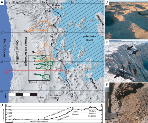
Fig. 1.
Catchments and characteristic features of the late Pleistocene riparian systems. (A) Regional map of northern Chile showing study area in relation to the approximate maximum extent of paleolake Tauca. Green and orange lines enclose surface water catchments mentioned in the text (green where the trunk stream is ephemeral and bordered by late Pleistocene wood-bearing sediments; orange where the trunk stream is perennial). Tp, Tarapacá; Ch, Chacarilla; C, Chipana; G, Guatacondo; M, Maní; S, Sipuca; Tb, Tambillo. (B) Topographic cross-section (located along X—X′ in A). (C) Photograph of T2 surface at Tb. Note the numerous excavated “mounds” dotting the landscape, indicating the vast expanse of organic Pleistocene deposits. In D, black arrows indicate logs transported within late Pleistocene aggradational fill. (Notebook at left for scale.) (E) A S. molle leaf litter deposit at Tb.

