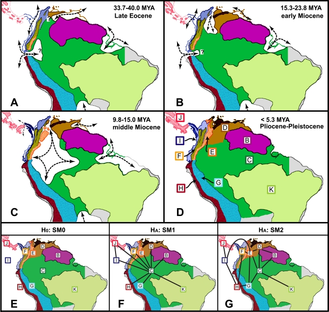
Figure 1. Biogeographic Areas, Extension of the Floodbasin System or Marine Incursions (Hatched Arrows), and Possible Connections within Cenozoic Paleogeographic Maps of Central and South America, Modified after Hoorn et al. and Diaz de Gamero.
(A–D) correspond to paleogeographic reconstruction of northern South America. (A) Early to late Eocene; (B) late Oligocene to middle Miocene; (C) middle to late Miocene; and (D) early Pliocene to the present. Uncertainties about the limit between biogeographic regions before the Pliocene are indicated by “?”. The hypotheses about the spatial configuration of biogeographic areas on the origin of Neotropical diversity are indicated in the panels (E–G) (input hypothesis matrices are provided in Figure S6). (E) The null model (H0: SM0), which assumes no spatial structure and equal rates of dispersal among all areas; (F) the center-of-origin model (HA: SM1), which assumes the Amazonia as the primary center of origin with widespread ancestral ranges constrained to include the Amazon Basin; and (G) the stepping-stone model (HA: SM2), which the assumes the historical spatial arrangement of biogeographic areas and constrains dispersals among geographically adjacent areas. The biogeographic areas used in the DEC modeling are C, the Amazon Basin; B, Guiana Shield; D, Venezuelan Highlands and Trinidad and Tobago Islands; E, North Oriental Andes; F, North Occidental Andes; G, Central Oriental Andes; and H, Central Occidental Andes; I, Chocoan rainforest, Magdalena Valley, and Gorgona Island; J, Central America west of the Gatun Fault Zone in Panamá; and K, the Brazilian Shield [14, 90].

