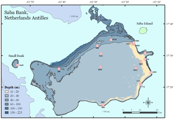
Figure 1. Map of Saba Bank, Netherlands Antilles.
Sites assessed during the January 2006 survey are indicated by circles with corresponding name abbreviations (BrF, Brown Fields; CV1, Coral Gardens first location; CV2, Coral Gardens second location; GB, Grouper Bank; MB1, Moonfish Bank first location; MB2, Moonfish Bank second location; MB3, Moonfish Bank third location; NE, North East Reef; PB, Poison Bank; RB3 Redman Bulge; RDF, Red Flats; RR, Rhodolith Reef; RVH, Rendez Vous Hill; SR1, South Reef first location; SR2, South Reef second location; SWC, Seaweed City; and RdF, Red flats. One site was assessed on Small Bank (SmB). The light green polygon depicts the island of Saba. A pale band of color representing 11–20 m depths represents a “fore reef” extending 50 km along the east and southeast perimeter of the Bank.

