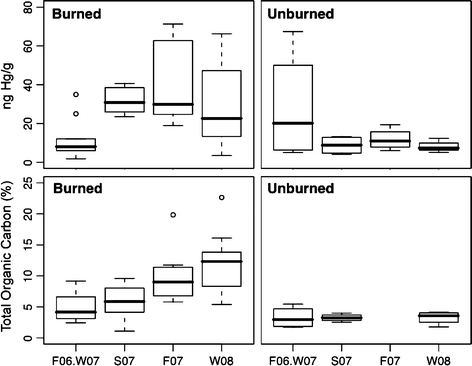
Fig. 7.

Boxplots representing the seasonal Hg concentrations at the soil surface (0 and 2.5-cm depth intervals) for the burned (top, left; n = 10: F06/W07, F07, and 8: S07, and 12: W08) and unburned sites (top, right (n = 4: F06/W07, S07, F07, and 3: W08)) and seasonal surface TOC levels in both burned (bottom, left (n= 10: F06/W07, S07, 8:F07, 12: W08)) and unburned soils (bottom, right (n = 4: F06/W07, S07, W08; 0: F07)) within Piru Creek watershed. Top and bottom edge of each box represents the 75th and 25th percentile, respectively; the line bisecting the box represents the median; circles are outliers
