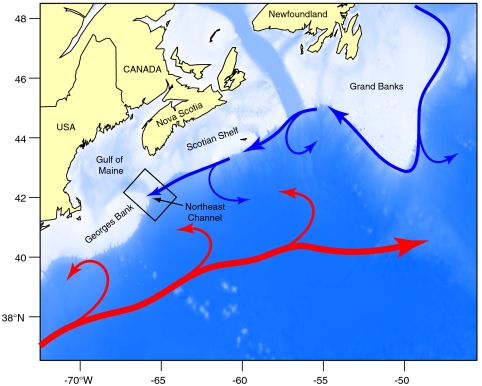
Fig. 1.
Map of the study area with location of Northeast Channel. Blue arrows mark the approximate position of the Labrador Current, which transports Labrador slope water (LSW) southward, along-slope. Red arrows show the location of the Gulf Stream. Warm slope water (WSW) occupies the region between the Gulf Stream and continental shelf edge. Temperature and nitrate data were extracted from the 2 × 2 degree grid centered over the Northeast Channel, from 150 to 250 m water depth, where interannual variability is most pronounced (18). Temperature data are from the Bedford Institute of Oceanography hydrographic database. Nutrient data are from the Biochem database of Fisheries and Oceans Canada (44).

