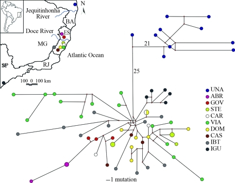
Figure 1.
Map of localities sampled for A. cursor in eastern Brazil and median-joining network of haplotypes. Circle sizes are proportional to haplotype frequency and each circle is colour coded according to the haplotype's presence at the sampling locations. Unobserved haplotypes are represented by small red circles. Branches are proportional to the number of mutations, except for those with numbers, which represent highly divergent haplotypes with more than 10 mutations. Acronyms, geographic coordinates and altitude of localities are: Bahia state, municipality of Una (UNA, 15°16' S, 39°04' W, 66 m), Espírito Santo state, municipalities of Águia Branca (ABR, 18°52' S, 40°49' W, 373 m), Governador Lindenberg (GOV, 19°16' S, 40°28' W, 220 m), Santa Teresa (STE, 19°55' S, 40°36' W, 950 m), Cariacica (CAR, 20°16' S, 40°25' W, 780 m), Viana (VIA, 20°24' S, 40°29' W, 25 m), Domingos Martins (DOM, 20°22' S, 40°40' W, 701 m), Castelo (CAS, 20°36' S, 41°11' W, 262 m) and Ibitirama (IBI, 20°29'S, 41°43'W, 935-1063 m), and São Paulo state, municipality of Iguape (IGU, 24°42' S, 47°34' W, 144 m).

