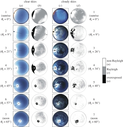
Figure 5.
(a,c) 180° field-of-view colour photographs of Tunisian clear and partly cloudy skies as a function of the solar elevation angle θS from the horizon. The centre/perimeter of the circular pictures is the zenith/horizon, and the zenith angle ψ is proportional to the radius from the centre (ψzenith = 0°, ψhorizon = 90°). (b,d) Maps of the proportion r of the sky that follows the pattern of the angle of polarization αRayleigh predicted by Rayleigh's theory of first-order scattering for clear skies in the red (650 nm), spectral range versus solar elevation angle θS. ‘Rayleigh’ points with Δα = |αmeasured − αRayleigh| ≤ 5° are shaded in grey, ‘non-Rayleigh’ points with Δα > 5° are white, and overexposed points are black. Hence, the grey/white celestial regions are appropriate/inappropriate for sky-polarimetric navigation by Vikings, while nothing is known about the black areas. The radial bar in the circular pictures is the wire of the Sun occulter. The approximately hourly positions of the Sun are represented by dots or the disc of the Sun occulter. The numerical values of r, n and o in rows 1–7 of tables S2 and S3 in the electronic supplementary material were determined for these clear and partly cloudy skies.

