Abstract
In debates on societal collapse, Iceland occupies a position of precarious survival, defined by not becoming extinct, like Norse Greenland, but having endured, sometimes by the narrowest of margins. Classic decline narratives for late medieval to early modern Iceland stress compounding adversities, where climate, trade, political domination, unsustainable practices, and environmental degradation conspire with epidemics and volcanism to depress the Icelanders and turn the once-proud Vikings and Saga writers into one of Europe's poorest nations. A mainstay of this narrative is the impact of incidental setbacks such as plague and volcanism, which are seen to have compounded and exacerbated underlying structural problems. This research shows that this view is not correct. We present a study of landscape change that uses 15 precisely dated tephra layers spanning the whole 1,200-y period of human settlement in Iceland. These tephras have provided 2,625 horizons of known age within 200 stratigraphic sections to form a high-resolution spatial and temporal record of change. This finding shows short-term (50 y) declines in geomorphological activity after two major plagues in A.D. 15th century, variations that probably mirrored variations in the population. In the longer term, the geomorphological impact of climate changes from the 14th century on is delayed, and landscapes (as well as Icelandic society) exhibit resilience over decade to century timescales. This finding is not a simple consequence of depopulation but a reflection of how Icelandic society responded with a scaling back of their economy, conservation of core functionality, and entrenchment of the established order.
Keywords: tephrochronology, soil erosion, human impact
Our overall aim is to refine understanding of the circumstances when societal collapse might occur through an assessment of a key potential driver of change (sudden population reduction) and a case of an apparent near miss (the endurance of Icelandic society through the later medieval to early modern period). The plagues of the historical period provide effective case studies of sudden population reduction. Iceland is the closest surviving North Atlantic community of Scandinavian descent to Norse Greenland. Through the 15th century, Icelanders avoided the extinction that befell their Greenlandic cousins, but they endured adversities of their own, including two outbreaks of plagues that killed large numbers of people.
Understanding how communities respond to abrupt population decline is a key element in both debates about collapse and the identification of putative drivers of social and environmental transformation. A number of quite different outcomes are possible. Where population collapse occurs in sedentary farming communities dependent on livestock (such as Iceland), the environmental impact of loss may be substantially different from the impact on societies supported by arable agriculture, where the environmental impacts of cultivation are closely linked to continued human activities (1, 2). Livestock can have a continued (and even increasing) impact without continued human involvement. In the absence of empirical data, it is not immediately obvious which outcome is most likely.
Environmental impact could increase with a disruption of grazing management that is exacerbated by labor shortages impacting fodder production. A reduced capability to provide winter feed and the unmanaged grazing of abandoned or feral livestock could increase winter grazing and hence, increase environmental impact (3). Alternatively, total landscape impact could have remained more or less the same or declined, but the spatial patterns could vary and lead to increased degradation in some areas, such as occupied farms, and reduced degradation in others, such as abandoned farms and upland areas. A third possibility is that environmental impact declines in all areas as livestock numbers fall to reflect the reduced human population. As a result, high-resolution, landscape-scale records that can track environmental change and reflect land management may provide key insight when combined with socioeconomic and political analysis.
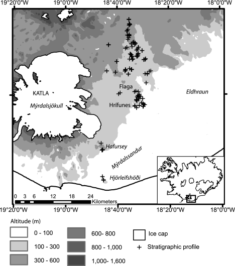
Skaftártunga in Iceland (Fig. 1) provides an ideal location to evaluate Iceland's near miss with collapse and consider episodes of population decline, contemporaneous landscapes, and landscape change in a sedentary farming system where livestock (principally, sheep and cattle) play a key role. There are high-resolution records of landscape change caused by high rates of aeolian sediment accumulation and the frequent occurrence of datable horizons of volcanic ash (tephra) in the soil. Tephrochronology provides a precise dating framework that may be applied at the landscape scale (4, 5), and in southern Iceland, there are well-placed marker horizons throughout periods of change. For the present study, it is particularly significant that the tephras closely bound discrete episodes of >30% population decline resulting from plagues in A.D. 1402–1404 and A.D. 1494–1495 (6).
Fig. 1.
Skaftártunga, Iceland, showing the locations of farms and stratigraphic profiles.
Pandemics, which can reduce population by >30%, such as with the Black Death in medieval Europe or pandemics after the European colonization of the Americas, have reduced arable farming relative to livestock farming (1) and resulted in limited reforestation (2). These changes are indicated by declines in cereal pollen (7), increases in pollen from pioneer species, such as Betula sp. (8), and reductions in charcoal frequency indicating reduced burning (2). However, these studies are limited by the precision and accuracy of radiocarbon dating and the use of relatively few sample sites, which may potentially mask small-scale spatial patterns. Variations in rates of sediment accumulation in Iceland give a sensitive indication of geomorphological change and can be precisely dated using tephra layers. This process permits the accurate reconstruction of past rates and patterns of landscape change, and these rates and patterns are used to assess the effects of large-scale and abrupt periods of human population decline in pastoral farming systems (5).
Iceland was spared the Black Death in the A.D. 1340s and 1350s, but in the 15th century, the country was twice hit by devastating epidemics that have been plausibly identified as plague. The first episode was in A.D. 1402–1404 and is estimated to have killed more than one-half of the population. Data from the mid-15th century suggest that, 40 y after the earlier plague, some 20% of farms were still deserted, indicating the potential scale of impact on both the economy and environment. A second epidemic came in A.D. 1494–1495, by which time the population had probably recovered from the earlier disaster. The mortality rate of the second plague was comparable in scale with the first plague; however, it is estimated to have killed less than one-half of the total Icelandic population, because it did not reach the Vestfjords, where some 10% of the population then lived (6).
The two 15th-century plague episodes in Iceland occurred at a time of rapid climatic change. The period of A.D. 1350–1500 can be seen as the transition from the generally warmer, more stable conditions of the Medieval Climate Anomaly to the generally cooler, less stable conditions of the Little Ice Age (9, 10). The synergistic effects of climate change and unrelated demographic shocks may produce a different impact than simple population decline. Population decline may potentially mitigate the impact of climate change on landscape and ecology. In addition, other trajectories of change and the legacy of past events may substantially influence the nature of any particular environmental fluctuation, and therefore, it is important to place episodes of population decline in a wider spatial and temporal context. This placement can be tackled in southern Iceland, because high-frequency tephrochronology can be applied across every part of the landscape with soil cover throughout the period of human settlement (the last ∼1,140 y) and back to the time of initial soil formation, which means that spatial patterns may be tracked through time with precision and accuracy.
Iceland's farming system was based primarily on sheep, cattle, goats, and horses and in the earliest centuries of settlement, pigs (11). Livestock was supported through the winter with fodder as well as some winter grazing. In the summertime, outfields and rangelands were exploited, which could belong to individual landowners or be communally managed. Crucially, subsistence was supported by the exploitation of wild resources: birds, eggs, marine mammals, and fish from both fresh water and the sea.
Presently, ∼40% of Iceland is classified as severely eroded (12). The majority of ecological changes occurred after the introduction of grazing livestock at settlement, with the reduction in total vegetation cover from ∼54% (13) to 28% (14). Despite the soil loss, there is still vegetation in eroded areas, and they continue to be grazed. Rates of sediment accumulation (SeAR) reflect erosion at both local (<250 m) and regional (>1 km) scales and can be used to reconstruct rates of landscape change (15, 16). If a landscape has minimal sediment movement, it indicates a degree of geomorphological stability and little progressive change; however, increasing SeARs indicate an increased sediment flux across the landscape and potential threshold-crossing ecological change.
Skaftártunga, Iceland: Study Area
Skaftártunga, south Iceland (Fig. 1), covers an area of 400 km2 (50–750 m elevation), and in A.D. 1703 (indicative of the situation in the 15th century), it contained 12 landholdings, with 16 households supporting 106 people and livestock comprising 933 sheep, 185 cattle, and 113 horses (17, 18). This low density of settlement is characteristic of Iceland before modern times, when there were no towns or other concentrations of settlement. As an inland district lying between the coastal lowlands and high ground of the uninhabited interior, where Betula spp. and Salix spp. woodland was present before settlement and winter grazing was possible even during cold decades, this area is typical of the best agricultural land in Iceland. Skaftártunga's economy was geared primarily to raising livestock, although the diet was probably supplemented to some degree by marine resources.
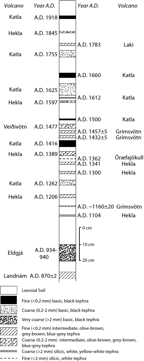
Skaftártunga's proximity to Iceland's four most active volcanic systems (Grímsvötn, Katla, Hekla, and Veiðivötn-Bárðarbunga) (19) means that the surface sediments contain 20 tephra produced in the past 1,200 y (20, 21), of which 15 are dated to the year against historical records. We recorded 200 stratigraphic profiles containing a total of 2,625 tephra layers of known age, with the majority of individual sections covering the whole period of human settlement in Iceland and 12 sections extending the record to 2.6 ka. The period between A.D. 1389 and A.D. 1597, which encompasses two major periods of plague, is constrained by seven tephra layers, providing a dating resolution of ∼30 y (Fig. 2). This spatially extensive, high-resolution record allows precise correlations at a range of scales to be made between settlement, population, and environmental change.
Fig. 2.
Composite tephrochronology of Skaftártunga for the past 1,140 y modified from refs. 20 and 21. Tephra layers on the right side are found less frequently, whereas those layers on the left side are found more frequently.
The work by Thórarinsson (22) noted that, after the A.D. 1693 eruption of Hekla, a farm affected by more than 25 cm of freshly fallen tephra was never resettled; farms affected by 10–15 cm were abandoned from between 1 and 4 y, whereas fallout less than 10 cm deep caused extensive damage but did not lead directly to abandonment. The most substantial layer found locally was formed by the Eldgjá eruption in A.D. 934–940 and frequently exceeds 10 cm in depth (mean depth = 21 cm); therefore, it is likely to have had a multiyear impact. Because all other historical age tephra falls in Skaftártunga are <10 cm in depth, they are all likely to have had a restricted impact, with the exception of the eruption of Laki in A.D. 1783 when fluorine poisoning, rather than the physical impacts of tephra fallout, coupled with particularly bad weather led to a nationwide famine that killed more than 20% of the total population of Iceland (23, 24).
Data
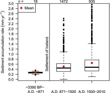
Before the settlement of Iceland in ∼A.D. 870, rates of SeAR primarily of aeolian origin were ∼0.3 mm/y, with low variation both spatially and over century timescales (15, 25). After settlement, the SeAR approximately doubles, with a mean of 0.6 mm/y after A.D. 1500 (Fig. 3). During the period of human settlement, variation across the landscape is high. Phases of increased sediment accumulation do not correlate with the impact of tephra fall, although when the depth of tephra is locally greater than 10 cm (∼4% of layers recorded), instability indicated by slope wash increases from <10% to ∼40%. Increasing SeARs after A.D. 1500 have been related to a combination of climatic deterioration and the migration of erosion fronts into deep lowland sediments (5).
Fig. 3.
Aggregate sediment accumulation rates for three periods: presettlement (∼3,390 B.P. to A.D. ∼870), A.D. 871–1500 (the Medieval Climate Anomaly), and A.D. 1500–2000 (the Little Ice Age and 20th century) for all measurements of SeAR. The outliers extend to maximum accumulation rates of 3.7 and 2.9 mm/y for the Medieval Climate Anomaly and Little Ice Age, respectively. Mean presettlement SeARs of 0.3 mm/y match measurements of 0.2–0.3 mm/y around Eyjafjallajökull from ref. 25.
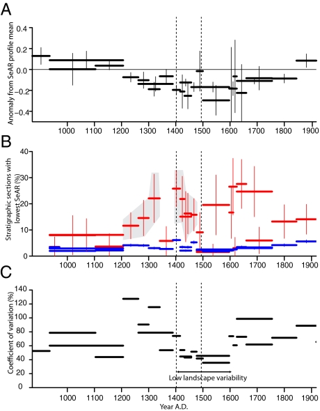
Although there is no difference in aggregate mean SeARs before, during, or after the period of plague in the early 15th century, additional indicators of landscape stability (deviation from mean accumulation in stratigraphic section, coefficient of variation, periods of lowest accumulation per profile over total profile age) show that the period A.D. 1389–1597 experienced lower than average landscape instability, which is consistent with a reduction in grazing pressure because of population decline (Fig. 4). High-resolution measurements from individual profiles show low accumulations between A.D. 1389 and A.D. 1416. It is the presence of all of these indicators that differentiate A.D. 1389–1416 from other periods that have similar low SeAR totals (i.e., A.D. 1597–1625 and A.D. 1206–1341). The period A.D. 1300–1341 has high variability in accumulation rates (120%) compared with the postplague period. The elevated SeARs in the period A.D. 1341–1389 could be explained by a series of cold years and heavy sea ice in this period (26). The period A.D. 1597–1660 is different, because variability increases in the landscape, indicating instability, and although some low totals for SeAR are found, in general, indicators of erosion rates are increasing (Fig. 5). The period from A.D. 1477 to A.D. 1597 has some indicators that are consistent with lower grazing impact after the plague in A.D. 1494–1495, but these indicators are not as clear as for A.D. 1389–1416. Some, but not all, of these differences may be because of the longer time between tephra layers in the later period and consequent reduction in resolution.
Fig. 4.
Broken vertical lines indicate the dates of the two plagues. The deviation in SeAR for each time period from the profile mean (as opposed to the regional mean) is shown in A. B shows the percentage of profiles that recorded the lowest or second lowest SeAR since settlement of Iceland in A.D. ∼870 (n ≥ 40). The red bars indicate the percentage and 95% confidence intervals, whereas the blue bars indicate the expected random percentage based on the proportion of age periods as a proportion of total age periods identified, with 95% confidence intervals indicated. Areas shaded in gray show where all of the age periods have significantly more low SeAR rates than could be expected by chance. C shows the coefficient of variation (percent variance of SD of mean), which indicates low variability from A.D. 1416 to A.D. 1597.
Fig. 5.
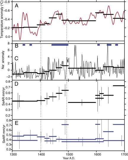
The period A.D. 1300–1700 sees substantial climatic changes in Iceland. A shows a multiproxy reconstructed sea surface temperature curve for the North Atlantic (10), with averages over the periods bounded by tephra indicated by black bars. (B) Periods of heavy sea ice (27). (C) Deviations from the mean in Na+ from the Greenland Ice Sheet Project 2 ice core, a proxy for storminess (28). (D) SeAR (error bars show 95% confidence intervals) from profiles at Hrífunes and Flaga landholdings (50–240 m elevation, n = 55 stratigraphic profiles), which show SeAR correlating closely with temperature. (E) SeAR from profiles above 250 m elevation (n = 64 stratigraphic profiles), which shows poor correlation with climatic signals.
Declines in SeARs in the period after the plagues are smaller in areas below 300 m elevation, suggesting that the impacts of population decline (and any synergistic effects) were not spread evenly over the landscape, with more ecologically marginal areas being affected by a greater reduction in SeARs. Indicators from two lowland farms (Fig. 1) (Hrífunes and Flaga landholdings, 50–240 m elevation, n = 55 stratigraphic sections recorded) show increasing SeAR through the 15th century (Fig. 5D) against the broader trend of decreasing geomorphological instability. This pattern of continuing erosion in lowland areas during a period of low population is consistent with two hypotheses. First, lowland areas are unlikely to be abandoned, because population after plague would still be ∼50–70% of previous levels; second, continued erosion may reflect changes or increases in more damaging land use practices, such as grazing outside the growing season (29) as a consequence of a reduced labor force, a decline in fodder production, and the consequent need to turn animals loose to forage.
Discussion
The possible environmental outcomes from sudden demographic decline are increases in impact, declines in impact, or changing spatial patterns of environmental impact. All are related to different social responses. We do not observe increases in SeARs and by implication, the related generation of sediment supply (erosion). Therefore, increased environmental impact, such as the impact produced by poorly managed or feral flocks of sheep, goats, and horses, is not associated with periods of population decline in this sedentary farming system, where livestock (principally, sheep and cattle) play a key role. A lower than expected phase of landscape instability in A.D. 1389–1597 is consistent with an overall reduction in grazing impact on the landscape. An indicator of pastoral retreat from marginal areas is a greater reduction in SeARs in areas above 300 m elevation, suggesting that environmental change after epidemics is similar to change in arable farming communities, even when subsistence may be based primarily on livestock. It indicates that, in the aftermath of the plague, not only was grazing management maintained, but there was no significant shift in terms of livestock mix from more labor-intensive cattle to less-demanding sheep.
One possible interpretation of our landscape-scale record through the plagues is that a cull of the human population simply eases environmental pressures. We would reject that interpretation. The consequences of both the plague years and other periodic stressors of medieval to early modern Icelandic society are not only seen in the avoidance of collapse, but they are also bound up with other possible outcomes that did not occur. In the aftermath of profound increases in mortality, the Icelanders did not either panic or succumb to apathy, both of which would have resulted in large flocks of sheep becoming feral. Unmanaged flocks of sheep are known historically to have survived for decades in the southern highlands of Iceland. In the A.D. 1860s, a flock of about 100 feral sheep lived in the highlands east of Skaftártunga, the descendants of two ewes and a ram that had escaped from a drive in A.D. 1820 (30). Typical January and February temperatures for south Iceland coastal plains oscillate around 0 °C (Kirkjubæjarklaustur weather station, A.D. 1926–2011: mean = 0.01 °C, minimum = −4.1 °C, maximum = 4.8 °C), and the area supported Betula spp. and Salix spp. woodland before settlement. Numerical modeling indicates that, under a climatic scenario of −1.5 °C from the mid-20th century mean temperature (comparable with the cooling seen in the 15th century), there is likely to have been sufficient areas of winter grazing available to sustain unmanaged domestic livestock (31). One important reason that this occurrence did not happen is because livestock in 15th century Iceland was the basis of individual wealth; for livestock to become a common resource would have torn apart the fabric of society.
In addition, there is no evidence that Icelanders reacted opportunistically and abandoned or reduced the more labor-intensive cattle raising in favor of keeping larger numbers of sheep, which in many ways, would have been an ideal solution to what must have been an acute lack of manpower and the need to maintain food production. This finding is all of the more remarkable, because sheep ratios had been rising at least since the 12th century, most noticeably in the smallest farms. The big change in sheep numbers in Skaftártunga did not come until early modern times. The history of this development is not known in the sort of detail that we would like, but the main outlines are clear; there are no indications that the ratio rose faster in the 15th or early 16th centuries than before or after. It is likely that, in the aftermath of the plague, people acted to conserve the core functionality of the economy; despite the labor requirements, they scaled back to more balanced ratios of cattle to sheep and preserved their cattle herds, which in Skaftártunga, were maintained into the early A.D. 1700s.
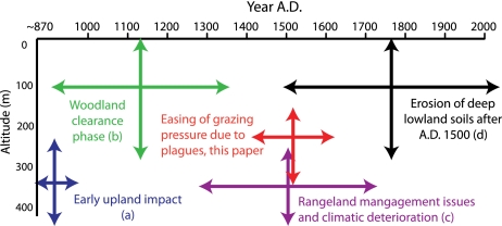
Existing models of degradation based on spatial and temporal variations in SeARs can be synthesized to create a model for the period of settlement (Fig. 6). Previous studies (5, 15, 29, 32) have identified five main trends in land degradation and SeARs in Iceland over the last 1,200 y. SeARs for Skaftártunga are evaluated against this integrated spatiotemporal model of erosion (Fig. 6), and all five previously identified trends can be shown to act together. Where we have 12th century dating control (Hekla A.D. 1104 tephra, n = 56 stratigraphic profiles), increases in SeARs related to the initial settlement period (the introduction of grazing, woodland clearance, and impact of a ∼20-cm deep tephra fall in the 10th century) have declined by the 12th century. Where this dating control is lacking, increases in SeAR seem to persist through the 12th century; however, it is likely that a decline in SeARs started sooner.
Fig. 6.
Synthesized model of soil erosion in Iceland from A.D. ∼870 to present [models based on a (15), b (32), c (29), and d (5)].
The key role of human actions in shaping landscape resilience can be seen in post-A.D. ∼870 increases in sediment movement that contrast with the long records of limited soil cover change and low SeARs observed before human colonization. These stable landscapes persist despite repeated Little Ice Age-scale events (15, 25, 33, 34). Where increases of SeARs have been observed in prehistory (35), it is likely that they have been driven by the increased sediment supply generated by large eruptions such as Hekla 3 and Hekla 4; each of these events deposited substantial (cubic kilometer scale) volumes of fine-grained tephra in the highlands that provided a supply of aeolian sediment into the lowlands for centuries after initial deposition. The overall decline of landscape resilience during the settlement period is apparent in a combination of detailed and well-dated records of landscape change (15, 25), archaeological evidence of changing livestock management (11), written records, and paleoclimatic data.
Separating the factors that trigger erosion, which are primarily grazing, and the factors that control the propagation of erosion, which are primarily the intensity of physical climatic processes (5), improves understanding of different responses to climatic deterioration (Fig. 5). If climate was the primary driver of geomorphic change, then we would expect landscape instability to have increased in a phase of ecologically unfavorable climate (such as the conditions found from A.D. 1420 to A.D. 1500) by reducing biomass formation, increasing the relative impact of grazing, and exacerbating erosion by wind, water, and ice formation (5). In lowland areas where there was likely to have been continuity in grazing intensity, changes in SeAR mirror changes in temperature and storminess (Fig. 5D). In contrast, in upland areas, there is no increase in SeAR, indicating that grazing intensity declined (Fig. 5E). Climatic deterioration after A.D. 1600 does correlate with increasing SeAR in all areas. The earlier period (A.D. 1400–1500) had a lower than average population caused by disease, whereas the later period (A.D. 1600–1700) probably had a population above the 50,000 level seen at the start of the 18th century (36, 37). This finding could explain why the geomorphic signal is spatially differentiated in A.D. 1400–1500 (because it is partially driven by variations in grazing pressure), whereas the transition at ∼A.D. 1600 occurs at all altitudes (Fig. 5), suggesting that climate is the primary driver.
Geomorphic thresholds of erosion in deeper lowland soils are known to have been crossed around Eyjafjallajökull after A.D. 1510 (5), but in Skaftártunga, with better chronological control, they can be shown to have taken place after A.D. 1597. This finding coincides with climatic deterioration. Climatic conditions during the period of A.D. 1450–1500 were similar but are not associated with increases in erosion. The delayed onset of threshold-crossing soil erosion could be a result of lower grazing pressure because of the maintenance of cattle herds and limited development of sheep flocks. Despite large demographic changes, the complex socioecological system of the farming communities of southern Iceland did not collapse or change, but the consequence was large-scale, effectively irreversible transformation of landscapes.
Conclusion
Environmental effects related to periods of demographic decline can be detected in geomorphic records at local and landscape scales provided that high-resolution chronological control is available. Tephrochronology produces effective datasets because of the potential to identify multiple horizons dated to the year across entire landscapes where soils are present. In 15th century Iceland, environmental impact scales linearly with population levels.
The adaptations in Iceland in the 15th century did meet the challenges that came with the Little Ice Age; in contrast, the effective 13th and 14th century adaptations of the Norse in Greenland did not meet the challenges of the 15th century (38). Adaptations in Iceland promoted landscape resilience and could have played a role in ensuring continuity of settlement in Iceland during the Little Ice Age.
This response of landscapes to episodes of abrupt and large-scale population decline is not immediately obvious, because domestic livestock are not directly impacted by human diseases and may continue to impact landscape independent of the human populations who originally created them. In addition, population decline may encourage an adaptive response to boost numbers of less labor-intensive livestock (sheep and goats) and reduce herds of more labor-intensive animals (cattle). In southern Iceland, there are no indications that abrupt population decline precipitated enhanced environmental impact, and therefore, those episodes did not result in changes in the livestock mix or badly managed or feral populations of sheep and goats. The plagues and resultant demographic shocks in 15th century Iceland did not propagate into collapse, indicating that this social–ecological system was resilient. Indeed, comparatively short-lived periods of grazing pressure reduction (decades) resulted in long-term (centuries) benefits in terms of enhanced resilience to climate change.
Scaling back and conserving core functionality was perhaps not a dynamic response, but it was also not the easy response to the crises of the 15th century. It reveals both a functional resilience as well as an ideological one; despite calamity on such an enormous and unprecedented scale that it must have led to questioning about the viability of the socioeconomic order, people seem to have maintained confidence in the basic soundness of their system and belief that it would recover if its basic premises were not allowed to become derailed. Their belief proved them right, even if one of the side effects may have been reduced dynamism and further entrenchment of the established order. Echoes of these choices can be heard today, because we face similar options of continuity or change and the potential tradeoffs that both involve.
Materials and Methods
High background sediment accumulation rates (on average, 0.55 mm/y after A.D. ∼870) ensure that tephras can be readily distinguished within the stratigraphy. The majority of tephra layers were field identified based on color, particle size, and their position in the stratigraphy using published tephrochronolgies (20, 21). Electron microprobe analysis based on standard techniques (39) from two reference sections confirmed the source volcano of tephras for the post-Landnám sequence. The ages of tephras were obtained from radiocarbon dating of associated organic sediments (Silicic Katla tephra Lower Needle (SILK-LN) and Silicic Katla tephra Upper Needle (SILK-UN)) (40), ice cores [Landnám (41) and Eldgjá (20, 42)], correlation with historical records of eruptions [eruptions of Hekla in A.D. 1104, 1206, 1300, 1341, 1389, 1597, and 1845 (43), Katla in A.D. 1262, 1416, 1500, 1612, 1625, 1660, 1755, and 1918 (44, 20), and Veiðivötn in A.D. 1477 (45)], and repeated measurements of sediment accumulation to ±1-mm precision from two sediment profiles [tephra from an eruption of Grímsvötn in A.D. 1432 ± 5 (1 SD), n = 985, and A.D. 1457 ± 5 (1 SD), n = 975]. Nontephra was recorded as aeolian material (grain size < 2 mm) and fluvial material (grain size > 2 mm) to distinguish regional and local sediment sources (16).
Acknowledgments
Meteorological data was provided by Guðrún Gísladóttir of the Icelandic Met Office. This work was supported by UK Natural Environment Research Council Grant NE/F00799X/1, UK Leverhulme Trust Grant F/00152/QA, and US National Science Foundation Grants 0732327 and 1042951.
Footnotes
The authors declare no conflict of interest.
This article is a PNAS Direct Submission. G.E. is a guest editor invited by the Editorial Board.
References
- 1.Yeloff D, van Geel B. Abandonment of farmland and vegetation succession following the eurasian plague pandemic of AD 1347–52. J Biogeogr. 2007;34:575–582. [Google Scholar]
- 2.Nevle RJ, Bird DK. Effects of syn-pandemic fire reduction and reforestation in the tropical Americas on atmospheric CO2 during European conquest. Palaeogeogr Palaeoclimatol Palaeoecol. 2008;264:25–38. [Google Scholar]
- 3.Simpson IA, et al. Soil limitations to agrarian land production in premodern Iceland. Hum Ecol. 2002;30:423–443. [Google Scholar]
- 4.Lowe DJ. Tephrochronology and its application: A review. Quat Geochronol. 2011;6:107–153. [Google Scholar]
- 5.Dugmore AJ, Gísladóttir G, Simpson IA, Newton A. Conceptual models of 1200 years of Icelandic soil erosion reconstructed using tephrochronology. J North Atlantic. 2009;2:1–18. [Google Scholar]
- 6.Karlsson G. Plague without rats: The case of 15th-century Iceland. J Mediev Hist. 1996;22:263–284. [Google Scholar]
- 7.Hall VA. Vegetation history of mid- to western Ireland in the 2nd millennium ad; fresh evidence from tephra-dated palynological investigations. Veg Hist Archaeobot. 2003;12:7–17. [Google Scholar]
- 8.Lagerås P. The Ecology of Expansion and Abandonment: Medieval and Post-Medieval Land-Use and Settlement Dynamics in a Landscape Perspective. Stockholm: Riksantikvarieämbetet; 2007. [Google Scholar]
- 9.Dawson A, et al. Historical storminess and climate, see-saws’ in North Atlantic region. Mar Geol. 2004;210:247–259. [Google Scholar]
- 10.Mann ME, et al. Global signatures and dynamical origins of the Little Ice Age and Medieval Climate Anomaly. Science. 2009;326:1256–1260. doi: 10.1126/science.1177303. [DOI] [PubMed] [Google Scholar]
- 11.McGovern TH, et al. Landscapes of settlement in northern Iceland: Historical ecology of human impact and climate fluctuation on the millennial scale. Am Anthropol. 2007;109:27–51. [Google Scholar]
- 12.Arnalds O, et al. Soil Erosion in Iceland. Reykjavik, Iceland: Soil Conservation Service and Agricultural Research Institute; 2001. [Google Scholar]
- 13.Ólafsdóttir R, Schlyter P, Haraldsson H. Simulating Icelandic vegetation cover during the Holocene. Implications for long-term land degradation. Geogr Ann Ser A. 2001;83A:203–215. [Google Scholar]
- 14.LMI (The Icelandic Geodetic Institute) Digital Vegetation Index Map of Iceland, Technical Report. Reykjavik, Iceland: The Icelandic Geodetic Survey; 1993. [Google Scholar]
- 15.Dugmore AJ, Buckland P. In: Environmental Change in Iceland: Past and Present. Maizels JK, Caseldine C, editors. The Netherlands: Kluwer, Dordrecht; 1991. pp. 147–159. [Google Scholar]
- 16.Dugmore AJ, Erskine CC. In: Environmental Change in Iceland. Stötter J, Wilhelm F, editors. Munich: Munchener Geographische Abhandlungen; 1994. pp. 63–78. [Google Scholar]
- 17.National Archives of Iceland Livestock . Census 1703. Reykjavík, Iceland: National Archives of Iceland; [Google Scholar]
- 18.Magnússon A, Vidalín P. Manntal á Ísland árið 1703. Reykjavik: Hagstofa; 1924. [Google Scholar]
- 19.Larsen G, Eiríksson J. Late quaternary terrestrial tephrochronology of Iceland—frequency of explosive eruptions, type and volume of tephra deposits. J Quaternary Sci. 2008;23:109–120. [Google Scholar]
- 20.Larsen G. Holocene eruptions within the Katla volcanic system, south Iceland: Characteristics and environmental impact. Jökull. 2000;49:1–28. [Google Scholar]
- 21.Óladóttir B, Larsen G, Thordarson T, Sigmarsson O. The Katla volcano s-Iceland: Holocene tephra stratigraphy and eruption frequency. Jökull. 2005;55:53–74. [Google Scholar]
- 22.Thórarinsson S. On the damage caused by volcanic eruptions with special reference to tephra and gases. In: Sheets PD, Grayson DK, editors. Volcanic Activity and Human Ecology. San Diego: Academic; 1979. pp. 125–159. [Google Scholar]
- 23.Thordarson T, Self S. Atmospheric and environmental effects of the 1783–1784 Laki eruption: A review and reassessment. J Geophys Res Atmospheres. 2003;108:4011. [Google Scholar]
- 24.Vasey DE. Population regulation, ecology, and political economy in preindustrial Iceland. Am Ethnol. 1996;23:366–392. [Google Scholar]
- 25.Dugmore AJ, Newton A, Larsen G, Cook G. Tephrochronology, environmental change and the norse settlement of Iceland. Environmental Archaeology. 2000;5:21–34. [Google Scholar]
- 26.Ogilvie AEJ. The past climate and sea-ice record from Iceland. 1. Data to AD 1780. Clim Change. 1984;6:131–152. [Google Scholar]
- 27.Massé G, et al. Abrupt climate changes for Iceland during the last millennium: Evidence from high resolution sea ice reconstructions. Earth Planet Sci Lett. 2008;269:565–569. [Google Scholar]
- 28.Meeker LD, Mayewski PA. A 1400-year high-resolution record of atmospheric circulation over the North Atlantic and Asia. Holocene. 2002;12:257–266. [Google Scholar]
- 29.Simpson IA, Dugmore AJ, Thomson A, Vésteinsson O. Crossing the thresholds: Human ecology and historical patterns of landscape degradation. Catena. 2001;42:175–192. [Google Scholar]
- 30.Aðalsteinsson S. Sauðkindin landið og Þjóðin. Reykjavik, Iceland: Bjallan; 1981. pp. 60–61. [Google Scholar]
- 31.Casely AF, Dugmore AJ. Good for glaciers, bad for people? Archaeologically relevant climate models developed from reconstructions of glacier mass balance. J Archaeol Sci. 2007;34:1763–1773. [Google Scholar]
- 32.Mairs KA, Church M, Dugmore AJ, Sveinbjarnardottir G. In: Degrees of Success: Evaluating the Environmental Impacts of Long Term Settlement in South Iceland, Publications from the National Museum, Studies in Archaeology and History. Arneborg J, Grønnow B, editors. Copenhagen: PNN; 2006. pp. 365–373. [Google Scholar]
- 33.Kirkbride MP, Dugmore AJ. Responses of mountain ice caps in central Iceland to Holocene climate change. Quat Sci Rev. 2006;25:1697–1707. [Google Scholar]
- 34.Kirkbride MP, Dugmore AJ. Two millennia of glacier advances from southern Iceland dated by tephrochronology. Quat Res. 2008;70:398–411. [Google Scholar]
- 35.Ólafsdóttir R, Guðmundsson HJ. Holocene land degradation and climatic change in northeastern Iceland. Holocene. 2002;12:159–167. [Google Scholar]
- 36.Thórarinsson S. Population changes in Iceland. Geogr Rev. 1961;51:519–533. [Google Scholar]
- 37.Karlsson G. Iceland's 1100 Years: The History of a Marginal Society. London: C. Hurst; 2000. [Google Scholar]
- 38.Dugmore AJ, et al. Collapse in a North Atlantic context. Proc Natl Acad Sci USA. 2012;109:3658–3663. doi: 10.1073/pnas.1115292109. [DOI] [PMC free article] [PubMed] [Google Scholar]
- 39.Dugmore AJ, et al. Radiocarbon dating tephra layers in Britain and Iceland. Radiocarbon. 1995;37:379–388. [Google Scholar]
- 40.Larsen G, Newton A, Dugmore AJ, Vilmundardóttir E. Geochemistry, dispersal, volumes and chronology of Holocene silicic tephra layers from the Katla volcanic system, Iceland. J Quat Sci. 2001;16:119–132. [Google Scholar]
- 41.Gronvöld K, et al. Ash layers from Iceland in the Greenland GRIP ice core correlated with oceanic and land based sediments. Earth Planet Sci Lett. 1995;54:238–246. [Google Scholar]
- 42.Vinther BM, et al. A synchronized dating of three Greenland Ice cores throughout the Holocene. J Geophys Res. 2006;111:1–11. [Google Scholar]
- 43.Thórarinsson S. 1–183. Reykjavik: Leiftur; 1967. The eruptions of Hekla in historical times. [Google Scholar]
- 44.Thórarinsson S. Katla and the Annals of Katla Eruptions. Arbók Ferdafélags Íslands, Reykjavik: 1975. pp. 125–149. [Google Scholar]
- 45.Larsen G. Recent volcanic history of the Veidivötn fissure swarm, southern Iceland—an approach to volcanic risk assessment. J Volcanol Geotherm Res. 1984;22:33–58. [Google Scholar]


