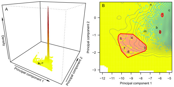
Figure 3.
Principal component analysis of geographic barriers identified by the topographic ring model. A: Density of all candidate barriers on the planet, with numbers corresponding to reference barriers known to promote ring speciation processes: (1) Ensatina: Central Valley, California, USA; (2) Acacia: Drakensberg Massif, South Africa; (3) Larus: Makarov Basin, Arctic Ocean; (4) Phylloscopus: Tibetan Plateau, Central Asia; (5) Phylloscopus: Takla Maka and Gobi Deserts, Central Asia; (6) Larus: Amundsen and Nansen Basins, Arctic Ocean; (7) Larus: Canada Basin, Arctic Ocean. Darker red tones correspond to higher barrier density; whitespace identifies areas where barriers are undefined (that is, non-existent). B: Vertical zoom on numbers 1 to 7 in A, showing in red the 100 closest cohesive candidate barriers (Euclidean distance) to the Ensatina and Acacia reference barriers (1 and 2), and the 1,380 cohesive candidate barriers identified for the bird taxa Larus and Phylloscopus and used to evaluate candidate composite barriers. Green points show the distribution of barriers where permeability as measured by fragmentation was less than the maximum possible. Lowercase letters show the locations of barriers evaluated in the discussion (b = Baja, c = Costa Rica, i = Iberian Peninsula, m = Madagascar, n = New Guinea). Black contours identify (from left to right) tiers of increasing density.

