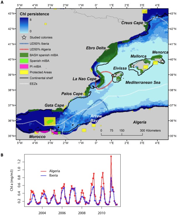
Figure 6. Oceanographic persistence at key marine areas.
(a) Persistence of chlorophyll a values in the western Mediterranean during the breeding period (February–June) of Balearic shearwaters. Values were obtained from the MODIS sensor between July 2002 and July 2011. For each pixel, we counted in how many years (maximum of 8) the concentration corresponded to high nutrient concentration (>0.3 mg m−3). Bluer areas correspond to persistent productive areas (check number of years on the scale bar). The position of the studied colony (white triangle), and the two key marine areas (indicated by the 50% UD) around Cape La Nao and Arzew Bay are placed. Limits of the continental shelf (200 m isobath) are defined by the black line, whereas Economic Exclusive Zones are delimited by dotted white lines [57]. In addition, limits of current Protected Areas are placed by yellow polygons in the western Mediterranean [56], as well as Spanish marine Important Bird Areas (mIBAs) for Balearic shearwaters (BASH) (dark green polygons), other Spanish mIBAs (light green polygons) and potentially important (PI) mIBAs in international waters (violet polygons) [18]. (b) Time series of chlorophyll a anomalies estimated for the two main marine areas based on kernel analysis. For each key marine area, we computed the chlorophyll a anomaly by estimating the global mean value and subtracting the global mean value to corresponding month.

