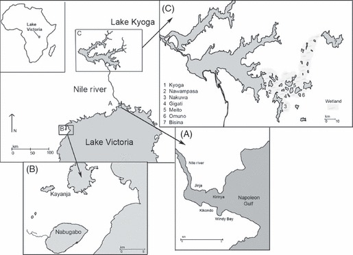
Figure 1.

Map of study sites within the Lake Victoria basin of East Africa, with sampling regions enlarged. The 10 lakes sampled for this study were: Victoria (A), Nabugabo (B), Kayanja (B), Kyoga (C), Nawampasa (C), Nakuwa (C), Gigati (C), Meito (C), Omuno (C) and Bisina (C). All contemporary (2008–2010) and historical (1966–2000) sampling on Lake Victoria was carried out in the Napoleon Gulf (A), a large sheltered bay on the northern shore of Lake Victoria, just upstream of the source of the Victoria Nile. The catchment is densely populated (587 people/km2) and encompasses Jinja, the second largest city in Uganda and a major national industrial centre. Lakes Nabugabo and Kayanja (B) are small satellite lakes on the Northwestern shore of Lake Victoria. The Lake Kyoga system (C) is comprised of over a dozen small, shallow lakes interconnected by extensive wetlands, which together span over 4700 km2 across the Ugandan districts of Kamuli, Pallisa, Kumi, and Soroti. The wetlands of the Kyoga system are dominated by dense stands of papyrus, Cyperus papyrus, and are considered to be one of the remaining pristine wetland areas in Uganda, due to their remote location and relatively low population densities. The Kyoga system is characterized by strong seasonal flooding during the two rainy seasons, and so water levels and connectivity among lakes may shift over time.
