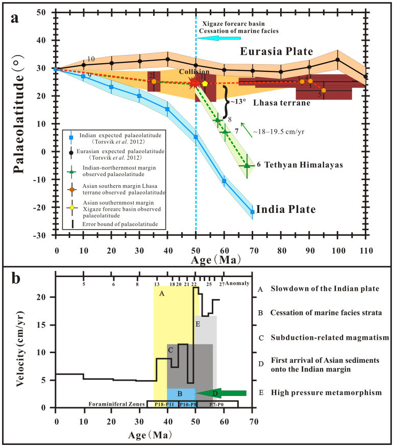
Figure 6. Plots of palaeolatitudes and related geologic evidence for India-Asia collision.
(a), Palaeolatitudinal comparison between the Asian and Indian margins (reference site, 29.9°N, 84.3°E). (b), Rate of convergence between India and Asia9 and other geological evidence for collision. Note: In (a), number ‘1' represents palaeolatitude for the Asian southernmost margin with 95% confidence limits on age and palaeolatitude from this study. Similarly, numbers ‘2, 3, 4, 5' are for the south Lhasa terrane margin: ‘2' is from upper Palaeogene volcanics results13,34, ‘3' and ‘5' are from Late Cretaceous E/I corrected redbeds (65–110 Ma)19 and volcanics intercalated with sediments19, and ‘4' is from Late Cretaceous E/I corrected redbeds (72–100 Ma)13. Numbers ‘6, 7, 8' indicate palaeolatitudes and uncertainties for the Himalayas estimated from autochthonous palaeomagnetic results isolated from the Zongshan (~65–71 Ma)42, lower Zongpu (~59–62 Ma) and upper Zongpu (~56–59 Ma) Formations43, respectively. Numbers ‘9' and ‘10' are the palaeolatitude curves for the southern margin of Eurasian (reference site, 29.9°N, 84.3°E) and the northern margin of India (reference site, 29.9°N, 84.3°E) derived from the Eurasian and Indian apparent polar wander paths of Torsvik et al. (2012)38. Numbers correspond to palaeomagnetic poles and palaeolatitudes listed in Supplementary Table S5. Confidence limits are illustrated as black dashed lines. Red and green lines stand for the southern and northern margins of Asia and India, respectively. In (b), ‘A–E' represent important geologic events during the collision. See text for details.

