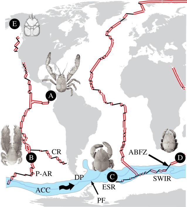
Figure 2.

Map showing locations of kiwaids, each with representative image, (A, K. puravida; B, K. hirsuta; C, Kiwa n. sp. ESR; D, Kiwa SWIR), as well as the location of the fossil Pristinaspina gelasina (E) in relation to mid-ocean ridges (MORs) and the ACC. Double lines denote actively spreading MOR segments; single black lines represent intervening faults and fracture zones. Land shapes and ridge positions are modified from the NASA Digital Tectonic Activity Map [12]. Spreading ridge abbreviations are as follows: P-AR, Pacific–Antarctic Ridge; CR, Chile Rise; ESR, East Scotia Ridge; SWIR, South West Indian Ridge; ABFZ, Andrew Bain Fracture Zone. Shaded area labelled ACC, Antarctic Circumpolar Current as defined by the Subantarctic Front to the north and the Southern ACC front to the south. PF, Polar Front. Wavy arrows illustrate direction of the ACC. DP denotes the Drake Passage. Photographs of K. puravida and K. hirsuta, courtesy of Shane Ahyong from Thurber et al. [11] and Macpherson et al. [2], respectively. (Online version in colour.)
