

Abstract
Thwaites Glacier is one of the largest, most rapidly changing glaciers on Earth, and its landward-sloping bed reaches the interior of the marine West Antarctic Ice Sheet, which impounds enough ice to yield meters of sea-level rise. Marine ice sheets with landward-sloping beds have a potentially unstable configuration in which acceleration can initiate or modulate grounding-line retreat and ice loss. Subglacial water has been observed and theorized to accelerate the flow of overlying ice dependent on whether it is hydrologically distributed or concentrated. However, the subglacial water systems of Thwaites Glacier and their control on ice flow have not been characterized by geophysical analysis. The only practical means of observing these water systems is airborne ice-penetrating radar, but existing radar analysis approaches cannot discriminate between their dynamically critical states. We use the angular distribution of energy in radar bed echoes to characterize both the extent and hydrologic state of subglacial water systems across Thwaites Glacier. We validate this approach with radar imaging, showing that substantial water volumes are ponding in a system of distributed canals upstream of a bedrock ridge that is breached and bordered by a system of concentrated channels. The transition between these systems occurs with increasing surface slope, melt-water flux, and basal shear stress. This indicates a feedback between the subglacial water system and overlying ice dynamics, which raises the possibility that subglacial water could trigger or facilitate a grounding-line retreat in Thwaites Glacier capable of spreading into the interior of the West Antarctic Ice Sheet.
Keywords: subglacial hydrology, radio glaciology, ice sheet stability
Thwaites Glacier is an outlet glacier in the Amundsen Sea Embayment (Fig. 1A), the most rapidly changing sector of the West Antarctic Ice Sheet (WAIS) (1–3) and a leading component of deglaciation scenarios (4–6). As such, the future stability of Thwaites Glacier is a significant factor in sea-level projections. Although subglacial water has been observed to cause significant acceleration in large Antarctic outlet glaciers (7), the potential for a similar (possibly destabilizing) subglacial-water-driven acceleration in Thwaites Glacier has not been geophysically assessed. Subglacial water systems have a diverse range of configurations (8) including lakes (9), sheets (10), canals (11), channels (11), and saturated tills (12); however, their control on ice flow is principally determined by whether the water is hydrologically distributed or concentrated (10). Distributed water systems are inefficient at drainage and increase basal lubrication with increased water flux, whereas concentrated water systems are efficient at drainage and do not increase basal lubrication (10). Therefore, the sensitivity of ice-flow acceleration and grounding-line stability for Thwaites Glacier will depend on the existence, locations, and interconnections of these two kinds of water systems beneath it.
Fig. 1.
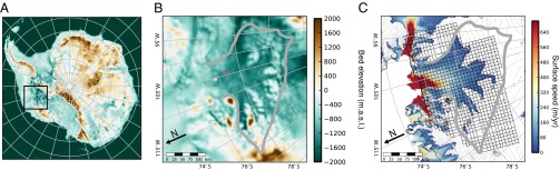
Thwaites Glacier, West Antarctica. (A) The bed elevation of the Thwaites Glacier catchment (black square) in the context of the marine West Antarctic Ice Sheet. (B) The bed elevation for only the Thwaites Glacier catchment (gray boundary). (C) The orthogonal 15-km survey grid of the Thwaites Glacier catchment shown in the context of ice-surface speeds above 35 m/y (28). The dark and light magenta dots show the locations for the radargrams in Fig. 4B.
Airborne sounding with ice-penetrating radar has the unique potential to provide both catchment-scale detection of water extent and meter-scale characterization of the geometrically expressed hydrologic state. Radar sounding is a long-established technique for acquiring ice thickness profiles and has been used to detect large subglacial water bodies as flat and bright surfaces in radargrams (13, 14). Subglacial water produces stronger echoes than grounded bed because it has a stronger dielectric contrast with the ice; however, echo-strength-based classifications are subject to ambiguities from temperature and chemical variations (15) within the overlying ice, which can lead to erroneous identification of water at the bed (16) and are insufficient to classify the dynamic state of detected water bodies. Such classification requires moving from a detection-centric approach to a measure of the angular distribution of returned energy that can be related to the meter-scale geometry, orientation, and hydrologic state of water systems.
Hydrologically distributed water systems are in pressure equilibrium with the overlying ice and their melt–freeze processes tend to produce planar reflecting interfaces (17). Concentrated water systems, by contrast, are not in pressure equilibrium and their water flow can melt channels into the ice with curved reflecting interfaces (11). This difference in reflecting interface geometry produces distinct radar scattering signatures that can be used as an indicator of the dynamic state of water systems. In this work, we apply range-migrated synthetic aperture focusing (18) to radar sounding data and quantify the angular distribution of returned energy in terms of a measure we call the specularity content of the bed echo. Specular interfaces produce sharp mirror-like reflections and diffuse interfaces scatter energy uniformly in all directions (19). Actual surfaces include both specular and diffuse components in their returned energy, and we define the specularity content of an interface to be the portion of the returned energy that is contributed by the specular component. To calculate the specularity content, we compare the focused echo strengths produced using different along-track apertures and determine what portion of the returned energy is contributed by specular reflection. Notably, specularity content only measures the angular distribution of energy in radar returns and is therefore insensitive to attenuation uncertainty from poorly constrained ice temperature and chemistry (15, 16).
The Thwaites Glacier catchment is the location of the most extensive coherent, gridded, airborne radar sounding survey in West Antarctica (20), with ice-penetrating radar data collected on a 15- × 15-km grid, using the 60-MHz HiCARS radar sounder (18) (Fig. 1). In this study, we performed range-migrated synthetic aperture radar focusing (18) on over 40,000 line-kilometers of coherent radar sounding profiles to produce two sets of radargrams focused over along-track apertures of 700 m and 2 km, making it possible to calculate the specularity content of bed echoes for the entire catchment.
Results
Our results show high specularity values in the upstream portion of the catchment that are localized and oriented along modeled hydrologic pathways (Fig. 2A), indicating flat distributed water bodies in equilibrium with the overlying ice. The orthogonal grid configuration for the survey (Fig. 1B) also makes it possible to examine each direction of the survey independently, showing that the bed echo specularity is highly anisotropic (Fig. 2 B and C). These results indicate that the subglacial water system is itself anisotropic, restricting the possible configurations of subglacial water to either distributed canals (8, 11) or concentrated channels (8, 11) (Fig. 3). Distributed canal systems are composed of networks of flat subglacial water bodies, tens of meters across, that are eroded into sediment at the ice–bed interface and increase basal lubrication with increased water flux. Concentrated channel systems are composed of networks of roughly semicylindrical subglacial water bodies, a few meters across, that are carved upward into the ice and largely do not affect basal lubrication (11).
Fig. 2.
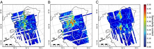
Echo specularity from an anisotropic subglacial water system. (A) The average of the bed echo specularity for orthogonal grid directions shown with the subglacial hydrologic pathways derived from surface and bed elevations (29).The bed echo specularity for the (B) north–south grid direction and (C) east–west grid direction.
Fig. 3.

Concentrated channels and distributed canals. Cartoon representations of the subglacial water configuration and radar scattering for (A) concentrated channels carved into the overlying ice with an approximately semicylindrical reflecting interface and (B) distributed canals eroded into the underlying sediment with an approximately planar reflecting interface (11).
The specularity content of bed echoes for Thwaites Glacier (Fig. 4A) shows high specularity values under the major tributaries and the upstream portion of the trunk, indicating substantial volumes of water ponding in distributed canals and increasing in area as it approaches a bedrock ridge (visible in Fig. 1B). Notably, a drop in specularity is evident downstream of the ridge, which could be the result of either of two phenomena: (i) the water system is trapped upstream of the ridge and water is not continuing downstream in sufficient quantities to be detected or (ii) the downstream water system has a different configuration that does not have a flat specular surface (e.g., concentrated channels). Distributed subglacial canals and concentrated subglacial channels have distinct morphologies and radar scattering signatures (Fig. 3). These indicate that a transition from distributed canals to concentrated channels should produce a significant decrease in specularity accompanying a comparatively high relative echo strength (21). The relative echo strength and specularity content for three major subglacial hydrologic pathways (Fig. 4B) show that in the upstream region specularity and relative echo strength do track one another closely and that in the downstream region specularity does fall as the bed echo strength remains high, matching the expected response for a canal to channel transition with significant quantities of water continuing to flow past the ridge to the grounding line in a concentrated network. This interpretation is supported by cross-flow focused radargrams (Fig. 4D) that show broad, flat reflectors (consistent with a network of distributed canals) underlie the region upstream of the transition, with bright returns coming from distinct scatters downstream of the transition (consistent with a network of concentrated channels).
Fig. 4.
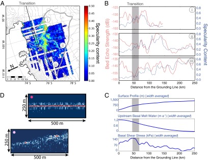
Transition from distributed canals to concentrated canals in Thwaites Glacier. (A) Specularity content in the context of subglacial hydraulic potential (contours) and tributary boundaries (black lines) showing high specularity values in the tributaries and upper trunk. Three major subglacial pathways (light gray lines) and the distributed-to-concentrated transition (black box) are also shown. (B) Bed echo strength and specularity content for three major subglacial pathways (with distributed-to-concentrated transition in gray). (C) The width-averaged surface profile, upstream basal melt water, and basal shear stress. (D) Focused cross-flow radargrams showing broad reflectors consistent with distributed canals (dark magenta dot) upstream of the transition and concentrated channels downstream (light magenta dot), each with ∼2,100 m of ice cover.
The transition from a distributed to a concentrated water system occurs with increasing surface slope and basal water flux (Fig. 4C), which are the conditions under which such a transition is predicted by theoretical studies of the regimes of stability for distributed canals and concentrated channels (11). The transition is also accompanied by an increase in basal shear stress (22), which is consistent with the theoretical expectations for the impact of such a transition on ice flow, with distributed canal systems reducing basal drag and concentrated channel systems having little or no effect (10).
Discussion
These results provide an attenuation-independent, catchment-wide characterization of the configuration and hydrologic state of the Thwaites Glacier subglacial water system. The system consists of a distributed network of canals ponding behind a bedrock ridge and feeding a system of concentrated channels downstream. Although the concentrated portion of the water system could occupy deeply incised channels like those observed on the deglaciated inner shelf (23), we do not observe deep water-filled basins, which are hypothesized as sources of melt-water floods capable of eroding those channels (23, 24). The transition from a distributed to a concentrated water system occurs with increasing surface slope, water flux, and basal shear stress, providing observational evidence for the theorized control of the ice surface on the configuration of subglacial water as well as the control of the subglacial water on ice flow. The effect of this direct feedback, like the effect of subglacial sedimentation processes (25), is likely to be temporary stabilization of the Thwaites grounding line through increased downstream basal traction until external forcing is strong enough to overcome that stabilization and produce a rapid retreat. This particular process and the general feedback between ice flow and subglacial water raises the possibility that subglacial hydrology could play a large, even dominant, role in evolution, stability, and potential retreat of Thwaites Glacier and the WAIS.
Materials and Methods
The radar data over Thwaites Glacier were collected (20) using a coherent ice-penetrating radar system (20) with a center frequency of 60 MHz and a 15-MHz bandwidth. We used coherent, range-migrated, synthetic aperture radar focusing that accounts for refraction at the air–ice interface to produce radargrams for two apertures of ∼700 m and 2 km. We determined the specularity content by comparing the focused energy produced by these two apertures and calculating the relative contributions of isotropic diffuse returns and narrow specular reflections. The specularity is calculated along each survey line and 5-km gridded specularity maps are produced for each of the two survey directions in addition to a specularity map from the average of these two orthogonal orientations, which is a proxy for the portion of the bed covered by specular reflectors with any orientation. We determined the major hydrologic pathways using gridded 5-km bed topography and ice-surface elevation using steepest descent to determine path direction (9). For the pathway profiles, we extracted specularity content from the 5-km gridded total specularity data and determined relative echo strength by empirically performing a distance and loss correction to account for englacial attenuation across the catchment (26). For the width-averaged plots, we extracted the surface profile from gridded surface elevations (27) and the basal shear stress from model-derived values (22) and averaged across the width of the glacier catchment. For the upstream subglacial melt-water plot, we used model-derived melt-water values (22), totaled the upstream melt water, and averaged across the width of the glacier catchment. We determined the location of the distributed-to concentrated-transition by investigating profiles across the entire catchment and identifying the point downstream of which the specularity and relative echo strength profiles stop tracking and begin to diverge with decreasing specularity.
Supplementary Material
Acknowledgments
Radar focusing algorithms and code were developed by M. Peters and S. Kempf. Radar interpretation was performed by J. DeSantos, A. Jones, M. Williams, and E. Powell. We thank G.K.C. Clarke and K. Matsuoka for their helpful comments on the manuscript. This work was supported by National Science Foundation (NSF) Grants PLR0636724 and PLR-0941678, National Aeronautics and Space Administration Grant NNX08AN68G, and the G. Unger Vetlesen Foundation. D.M.S. received support from a NSF Graduate Research Fellowship Program Fellowship, a University of Texas Recruiting Fellowship, and the University of Texas Institute for Geophysics (UTIG) Gale White Fellowship. This is UTIG Contribution 2567.
Footnotes
The authors declare no conflict of interest.
*This Direct Submission article had a prearranged editor.
This article contains supporting information online at www.pnas.org/lookup/suppl/doi:10.1073/pnas.1302828110/-/DCSupplemental.
References
- 1.Chen JL, Wilson CR, Blankenship DD, Tapley BD. Accelerated Antarctic ice loss from satellite gravity measurements. Nat Geosci. 2009;2(12):859–862. [Google Scholar]
- 2.Pritchard HD, Arthern RJ, Vaughan DG, Edwards LA. Extensive dynamic thinning on the margins of the Greenland and Antarctic ice sheets. Nature. 2009;461(7266):971–975. doi: 10.1038/nature08471. [DOI] [PubMed] [Google Scholar]
- 3.Rignot E, et al. Recent Antarctic ice mass loss from radar interferometry and regional climate modeling. Nat Geosci. 2008;1(2):106–110. [Google Scholar]
- 4.Bamber JL, Riva REM, Vermeersen BLA, LeBrocq AM. Reassessment of the potential sea-level rise from a collapse of the West Antarctic Ice Sheet. Science. 2009;324(5929):901–903. doi: 10.1126/science.1169335. [DOI] [PubMed] [Google Scholar]
- 5.Schoof CG. Ice sheet grounding line dynamics: Steady states, stability, and hysteresis. J Geophys Res. 2007;112(F3):1–19. [Google Scholar]
- 6.Weertman J. Stability of ice-age ice sheets. J Geophys Res. 1961;66(11):3783–3792. [Google Scholar]
- 7.Stearns LA, Smith BE, Hamilton GS. Increased flow speed on a large East Antarctic outlet glacier caused by subglacial floods. Nat Geosci. 2008;1:827–831. [Google Scholar]
- 8.Fountain AAG, Walder JJS. Water flow through temperate glaciers. Rev Geophys. 1998;36(3):299–328. [Google Scholar]
- 9. Wright A, Siegert MJ (2011) The identification and physiographical setting of Antarctic subglacial lakes: An update based on recent discoveries. Antarctic Subglacial Aquatic Environments (American Geophysical Union, Washington, DC), pp 9–26.
- 10.Creyts TT, Schoof CG. Drainage through subglacial water sheets. J Geophys Res. 2009;114(F4):F04008. [Google Scholar]
- 11.Walder JS, Fowler A. Channelized subglacial drainage over a deformable bed. J Glaciol. 1994;40(134):3–15. [Google Scholar]
- 12.Alley RB. Water-Pressure Coupling of Sliding and Bed Deformation: I. Water System. J Glaciol. 1989;35(119):108–118. [Google Scholar]
- 13.Oswald GKA, Robin G. Lakes beneath the Antarctic Ice Sheet. Nature. 1973;245(5423):251–254. [Google Scholar]
- 14.Carter SP, Blankenship DD, Young DA, Holt JW. Using radar-sounding data to identify the distribution and sources of subglacial water: Application to Dome C, East Antarctica. J Glaciol. 2009;55(194):1025–1040. [Google Scholar]
- 15.MacGregor JA, et al. Modeling englacial radar attenuation at Siple Dome, West Antarctica, using ice chemistry and temperature data. J Geophys Res. 2007;112(F3):F03008. [Google Scholar]
- 16.Matsuoka K. Pitfalls in radar diagnosis of ice-sheet bed conditions: Lessons from englacial attenuation models. Geophys Res Lett. 2011;38(5):L05505. [Google Scholar]
- 17.Oswald GKA, Gogineni S. Recovery of subglacial water extent from Greenland radar survey data. J Glaciol. 2008;54(184):94–106. [Google Scholar]
- 18. Peters ME, et al. (2007) Along-track focusing of airborne radar sounding data from West Antarctica for improving basal reflection analysis and layer detection. IEEE Trans Geosci Remote Sensing 45(9):2725–2736.
- 19.Nayar S, Ikeuchi K, Kanade T. Surface reflection: Physical and geometrical perspectives. IEEE Transactions on Pattern Analysis. 1991;13(7):611–634. [Google Scholar]
- 20.Holt JW, et al. New boundary conditions for the West Antarctic Ice Sheet: Subglacial topography of the Thwaites and Smith glacier catchments. Geophys Res Lett. 2006;33(9):L09502. [Google Scholar]
- 21. Knott EF, Shaeffer JF, Tuley MT (2004) Radar Cross Section (SciTech Publishing, Raleigh, NC)
- 22.Joughin IR, et al. Basal conditions for Pine Island and Thwaites Glaciers, West Antarctica, determined using satellite and airborne data. J Glaciol. 2009;55(199):245–257. [Google Scholar]
- 23.Nitsche FO, et al. Paleo ice flow and subglacial meltwater dynamics in Pine Island Bay, West Antarctica. Cryosphere. 2013;7(5):249–262. [Google Scholar]
- 24.Alley RB, et al. Outburst flooding and the initiation of ice-stream surges in response to climatic cooling: A hypothesis. Geomorphology. 2006;75(1-2):76–89. [Google Scholar]
- 25.Alley RB, Anandakrishnan S, Dupont TK, Parizek BR, Pollard D. Effect of sedimentation on ice-sheet grounding-line stability. Science. 2007;315(5820):1838–1841. doi: 10.1126/science.1138396. [DOI] [PubMed] [Google Scholar]
- 26.Gades AM, Raymond CF, Conway H, Jacobel RW. Bed properties of Siple Dome and adjacent ice streams, West Antarctica, inferred from radio-echo sounding measurements. J Glaciol. 2000;46(152):88–94. [Google Scholar]
- 27.Bamber JL, Gomez-Dans JL, Griggs JA. Antarctic 1 km digital elevation model (DEM) from combined ERS-1 radar and ICESat laser satellite altimetry. Cryosphere. 2009;3(1):101–111. [Google Scholar]
- 28.Rignot E, Mouginot J, Scheuchl B. Ice flow of the Antarctic ice sheet. Science. 2011;333(6048):1427–1430. doi: 10.1126/science.1208336. [DOI] [PubMed] [Google Scholar]
- 29.Le Brocq AM, Payne AJ, Siegert MJ, Alley RB. A subglacial water-flow model for West Antarctica. J Glaciol. 2009;55(193):879–888. [Google Scholar]
Associated Data
This section collects any data citations, data availability statements, or supplementary materials included in this article.