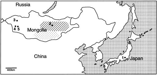
Figure 1.
Geographic map around East Asia. Sampling was performed on the following populations: Japanese in Kanagawa and Tokyo (1); Khalkh in Ulaanbaatar (2); Khoton in Tarialan, Uvs aimag (3); Uriankhai in Munkhkhairkhan and Duut, Khovd aimag (4); and Zakhchin in Mankhan and Zereg, Khovd aimag (5). Tarialan, Munkhkhairkhan, and Mankhan are bordered by the steep mountain district formed by part of the Altai Mountains. The hatched and dotted areas indicate the regions of the vast steppe and the Gobi desert, respectively. The Japanese population has the historical and demographic properties of an island population, which would make them a genetic isolate, like the Finnish (Graham and Thompson 1998). The Mongolian populations experienced a historical event in the 12th century. Their country, the “Mongol Empire,” expanded from the eastern steppe to the Near East, and then reduced to its modern size. In this century, although there were immigrations from Turkish and central Asian regions, these immigrants have settled in the mountainous district in western Mongolia (Nyambuu 1992; Badamkhatan 1996).

