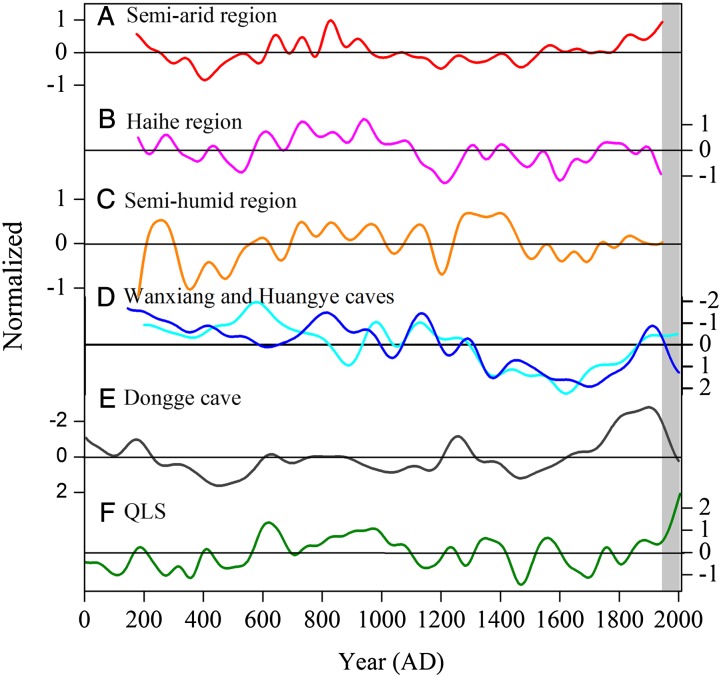
Fig. 4.
Multiple records of moisture variability in central and western China. A comparison of the last 2,000 y of the QLS precipitation reconstruction (F) with six relatively well-dated, published records indicative of moisture variability in western China. All records are normalized to have zero mean and unit SD and are smoothed to emphasize their multidecadal to centennial timescale variability. The first three series are independent reconstructions based on documentary records of the frequency of floods and droughts for (A) the semiarid area of the Great Bend of the Yellow River (26), (B) the Haihe River Basin (27), and (C) the semihumid lower reaches of the Yellow River Basin (26). The three “cave” records are oxygen isotope series (δ18O) derived from cave speleothems in (D) Wanxiang (28) (cyan) and Huangye (29) (blue) Caves, located very close to each other in southern Gansu some 700 km to the southeast of Dulan and (E) Dongge Cave (30), situated much further south (25°17'N, 108°5′E) in northern Guizhou some 1500 km from the region of the tree-ring data (Fig. 1 gives all locations). The Dongge Cave record has been widely interpreted as a proxy for summer monsoon intensity throughout the Holocene and has been linked with changes in Total Solar Irradiance (ref. 32 and SI Appendix).

