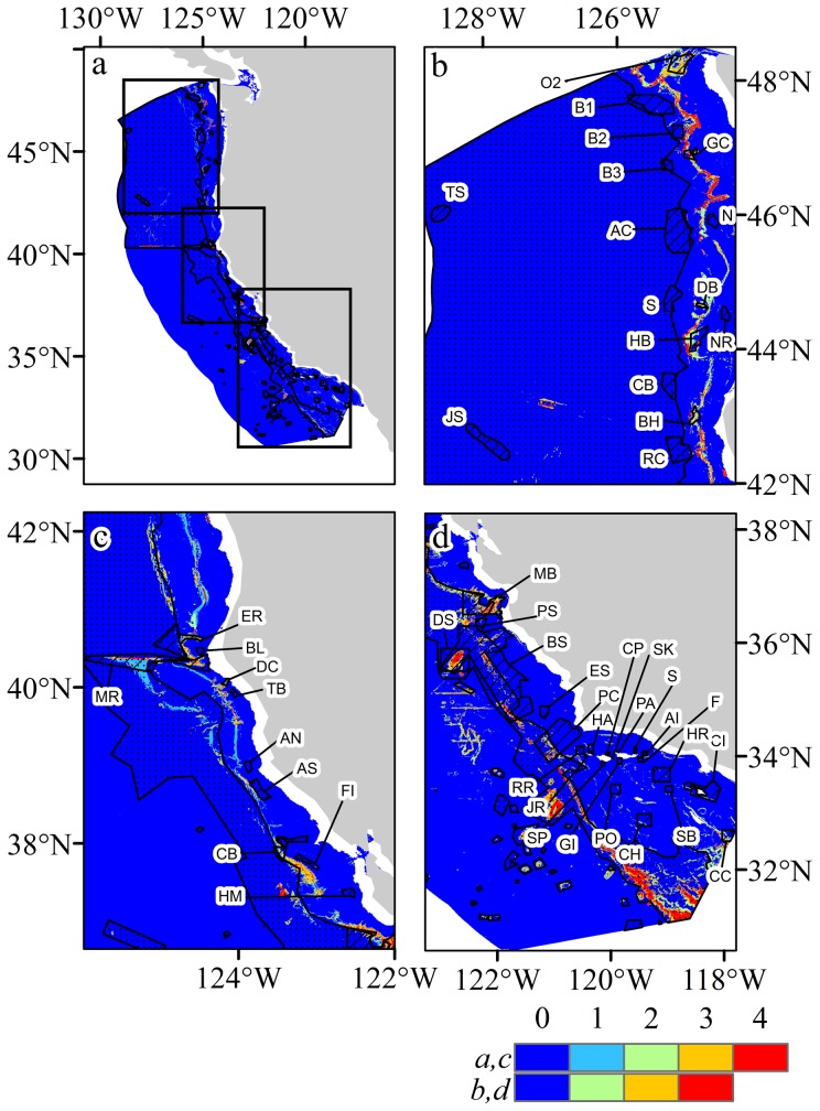
Figure 8. Spatial distribution of predicted habitat suitability and bottom trawl closures for areas designated Essential Fish Habitat (stippled) and CCA-West closures (hatched areas).
a) Overview with 0.75 threshold suitability for all taxa, b) northern region (Washington and Oregon) and prediction for Scleractinia, c) central region (northern California) and prediction for Scleraxonia, d) southern region (central and southern California) and prediction for Antipatharia. Location abbreviations: O2: Olympic 2, B1: Biogenic 1, B2: Biogenic 2, B3: Biogenic 3, GC: Grays Canyon, N: Nehalem Bank/Shale Pile, AC: Astoria Canyon, TS: Thompson Seamount, S: Siletz Deepwater, DB: Daisy Bank/Nelson Island, NR: Newport Rockpile/Stonewall Bank, HB: Heceta Bank, CD: Deepwater off Coos Bay, BH: Brandon High Spot, RC: Rogue Canyon, JS: President Jackson Seamount, ER: Eel River Canyon, BL: Blunts Reef, MR: Mendocino Ridge, DC: Delgada Canyon, TB: Tolo Bank, AN: Pt. Arena North, AS: Pt. Arena South, CB: Cordell Bank Biogenic Area, FI: Farallon Islands/Fanny Shaol, HM: Half Moon Bay, MB: Monterey Bay/Canyon, PS: Point Sur Deep, BS: Big Sur Coast/Port San Luis, DS: Davidson Seamount, ES: East San Lucia Bank, PC: Point Conception, RR: Richardson Rock, JR: Judith Rock, HP: Harris Point, CP: Carrington Point, SP: South Point, SK: Skunk Point, S: Scorpion, PA: Painted Cave, AI: Anacopa Island, F: Footprint, HR: Hidden Reef/Kidney Bank, CI: Catalina Island, CC: Cowcod Conservation East Area, SB: Santa Barbara, CH: Cherry Bank, PO: Potato Bank, GI: Gull Island.

