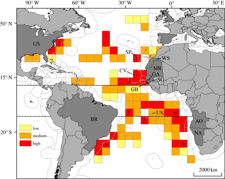
Figure 2.
Long-term susceptibility of leatherback turtle to bycatch in longline fisheries. This map shows where high-fishing-pressure areas overlapped with leatherback habitat use, between 1995 and 2010, in the Atlantic Ocean. Three classes were defined: low (high fishing pressure/low turtle use), medium (high fishing pressure/medium turtle use) and high susceptibility (high fishing pressure/high turtle use). Nine main high-susceptibility areas were identified (nos 1–9 on the map). These areas occurred both in international waters and in the EEZs of 12 countries (in dark grey) fringing the Atlantic, comprising eight in the northern Atlantic—Cape Verde (‘CV’, no. 4), Gambia (‘GA’, no. 4), Guinea Bissau (‘GB’, no. 4), Mauritania (‘MR’, no. 4), Senegal (‘SG’, no. 4), Canaries (Spain; ‘SP’, no. 3), United States of America (‘US’, no. 2), Western Sahara (‘WS’, no. 4)—and four in the southern Atlantic—Angola (‘AO’, no. 6), Brazil (‘BR’, nos. 5 and 8), Namibia (‘NA’, no. 6), Ascension Island (United Kingdom; ‘UK’, nos. 6 and 7). Dashed grey lines represent the limits of national EEZs. Broken lines represent latitudes 10° N and 10° S.

