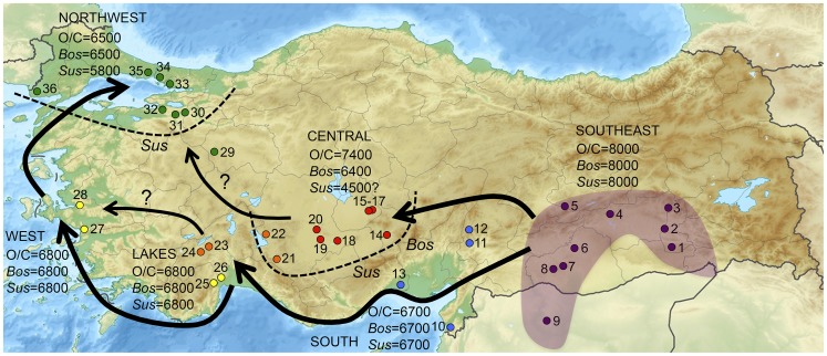
Figure 1. Map of Turkey showing the location of sites mentioned in this analysis.
Arrows indicate potential routes for the spread of domestic animals outside of the Fertile Crescent. Dates indicate an approximation of the first appearance of domesticated sheep/goat (O/C), cattle (Bos), and pigs (Sus) in six regions of Turkey. Dotted lines indicate boundaries where the listed domestic animals were not part of initial Neolithic economies. Southeast Region (purple) = 1. Hasankeyf, 2. Körtik Tepe, 3. Hallan Çemi, 4. Çayönü Tepesi, 5. Cafer Höyük, 6. Nevalı Çori, 7. Göbekli Tepe, 8. Yeni Mahalle, 9. Mureybet; South Region (blue) = 10. Üçağızlı, 11.Domuztepe, 12.Direkli Cave, 13.Yumuktepe; Central Region (red) = 14. Köşk Höyük, 15. Aşıklı Höyük, 16. Musular, 17. Güvercinkayası, 18. Pınarbaşı, 19. Çatalhöyük, 20. Boncuklu; Lakes Region (orange) = 21. Suberde, 22. Erbaba, 23. Höyücek, 24. Bademağacı; West/Coast Region (yellow) = 25. Karain B, 26. Öküzini, 27. Çukuriçi, 28. Ulucak; Northwest Region (green) = 29. Orman Fidanlığı, 30. Barcın, 31. Menteşe, 32. Ilıpınar, 33. Pendik, 34. Fikirtepe, 35. Yenikapı, 36. Hoca Çesme.

