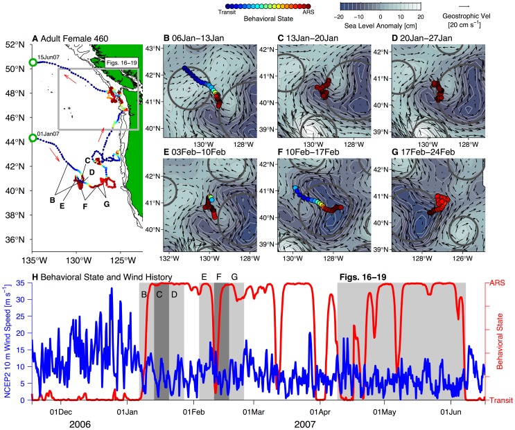
Figure 11. Behavioral responses of adult female northern fur seal 460 to mesoscale circulation and surface wind speed.
(A) Overview of satellite-tracked locations of female 460 in the California Current and Gulf of Alaska ecosystems from 01 January 2007 to 15 June 2007. Six h locations are colored according to estimated behavioral state (scale at top, ARS = area-restricted search). Gray box in panel A and gray shading in panel H indicates the spatial and temporal extent covered by Figures 16A–19A, when female seal 460 foraged in close proximity to the Seaglider region. (B)–(G) show weekly intervals of 460's estimated locations and behavioral state in 6 h periods (filled color circles, scale at top) plotted over sea level anomaly (color contours) and surface geostrophic velocity anomaly (Vel, black arrows, scale at top right). Each plot is centered on female seal 460's locations over the weekly period. Note that one weekly interval is omitted between panels D and E, during which time female seal 460 continued to forage in the same location as in panel D. Thick gray circles indicate the locations and approximate spatial extent of altimetry-identified mesoscale eddies from Chelton et al. [63]. Eddies are plotted as circular features though this is intended for illustration purposes only. (H) Plot of estimated behavioral state (red line, scale on right y-axis) and 10 m height wind speed (m s−1) at seal 460's location (blue line, scale on left y-axis) versus time for the overwintering period 2007–08. Wind speed estimates are obtained by interpolating National Centers for Environmental Prediction Reanalysis 2 (NCEP2) product to 460's estimated locations at each 6 h time point. Gray bars in alternating shading display the extent of time covered by panels B–G.

