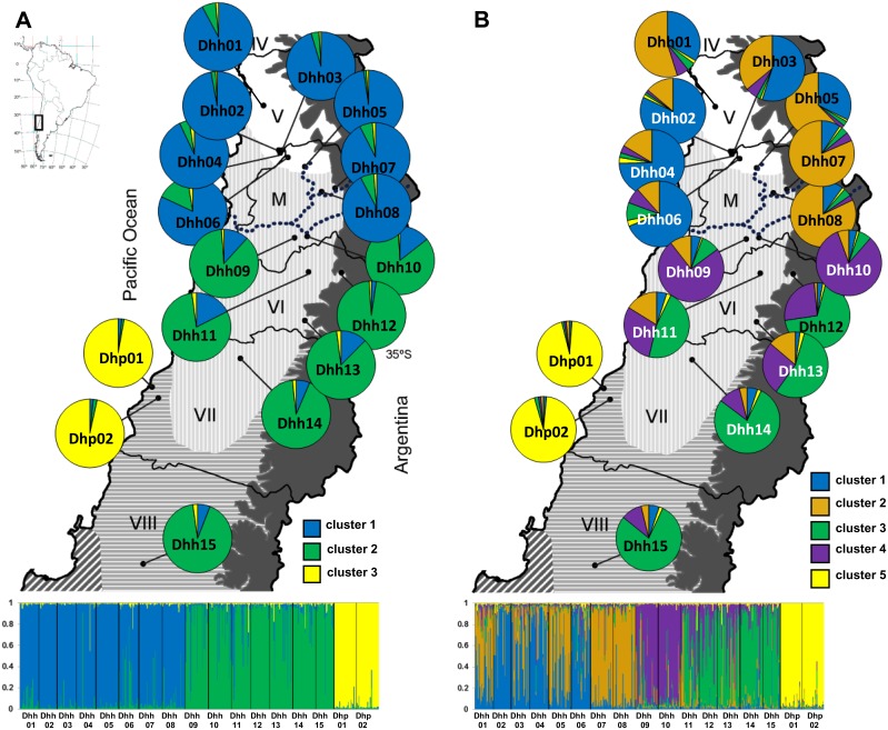
Figure 1. Geographical distribution of sampled populations of Dioscorea humilis in Chile (Table 1) and Bayesian analyses of the genetic structure of 15 populations of D. humilis subsp. humilis and two populations of D. humilis subsp. polyanthes based on nuclear microsatellite data.
The mean proportion of membership of each predefined population to each of the A, three (K = 3), and B, five (K = 5), most likely inferred genetic clusters is shown. The dotted line indicates the location of the Maipo river. Chilean administrative regions: IV, Coquimbo, V, Valparaíso, M, Metropolitana, VI, Libertador General Bernardo O’Higgins, VII, Maule, and VIII, Bío-Bío. Geographical ranges of five climatic zones in central Chile from Castillo et al., [20] are superimposed on the maps. From North to South: semiarid Mediterranean (white), sub-humid Mediterranean (vertical shading), humid Mediterranean (horizontal shading), hyper humid Mediterranean (diagonal shading) and eastern Andean Continental (solid grey). Map contour constructed from spatial data retrieved from http://www.diva-gis.org/gdata.

