
Figure 1.
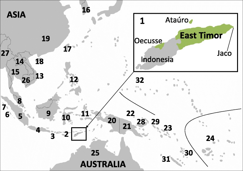
The geographic location of East Timor and the populations included in this study. 1 - East Timor, 2 - Nusa Tenggara, 3 - Bali, 4 - Java, 5 - Sumatra, 6 - Mentawai, 7 - Nias, 8 - Peninsular Malaysia, 9 - Borneo, 10 - Sulawesi, 11 - Moluccas, 12 - Philippines, 13 - Vietnam, 14 - Laos, 15 - Thailand, 16 - South Korea, 17 - Taiwan, 18 - Hainan, 19 - Mixed Han (China), 20 - WNG, 21 - PNG, 22 - Admiralty Islands, 23 - Solomon Islands, 24 – Polynesia/Fiji, 25 - Australia, 26 - Cambodia, 27 - Myanmar, 28 - New Britain and New Ireland (Bismarck Archipelago), 29 - Bougainville, 30 - Vanuatu, 31 - New Caledonia, 32 - Micronesia, 33 - New Zealand Maori (not on map). Populations 2–7, 9–11, and 20 are in Indonesia; 22, 28 and 29 in PNG. The population codes were retained throughout this study. For references see Additional file 11 where subpopulations are indicated with suffixes.