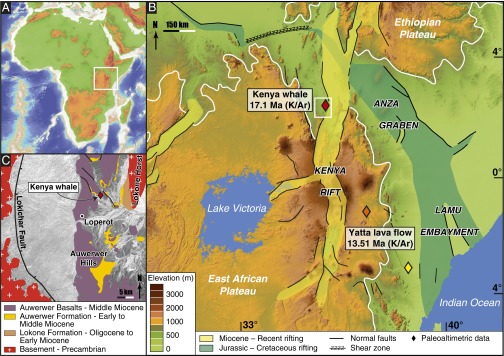
Fig. 1.

(A) Topography of Africa and bathymetry of the Atlantic and Indian Oceans. The white box indicates the location of the principal map shown in B. (B) Geological setting of the Cenozoic East African Rift System and topography of the present EAP based on a digital elevation model derived from Satellite Radar Topography Mission data. Elevations >1,000 m are enclosed by a white line. Rock ages for the basalt overlaying the beaked whale fossil and the Yatta lava flow phonolites are based on the radioactive decay of potassium (40K) into argon (40Ar). The white box indicates the location of the geological map in C. (C) Geological map of the Oligo-Miocene Lokichar Basin. The red diamond indicates the beaked whale fossil locality (Williams’ Flat) within the Lower to Middle Miocene Auwerwer Formation.
