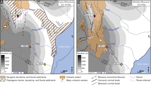
Fig. 3.

Topographic and drainage evolution in Kenya during the Miocene. Present Indian Ocean coastline, national borders, and Lake Turkana shoreline in the north for orientation. Paleoaltimetric data are shown by diamonds (red, Turkana whale; orange, Yatta lava flow beginning; yellow, Yatta lava flow end). A shows 23–16 Ma: uplift of the EAP to ∼1,000 m in Kenya (33, 34). The plateau area is drained by a major river network, which flows to the east into the Indian Ocean (IO) (29, 30). B shows 16–9 Ma: uplift of the EAP to 1,400 m in Kenya (29). The major river network still flows to the east, but minor rivers also drain to the west through surface downwarps on the EAP interior into the Lake Victoria (LV) basin (29, 30, 46).
