
Fig. 1.
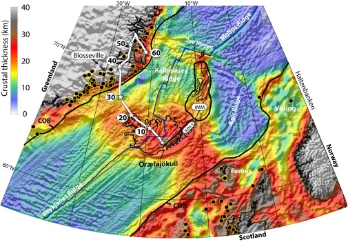
Crustal thickness map based on gravity inversion and revised location of the Iceland plume (white star symbols in 10-My intervals) relative to Greenland back to 60 Ma (see Fig. 6A for details). Transition between continental and oceanic crust (COB, black lines), plate boundaries (blue lines), site locations for dated North Atlantic Igneous Province magmatism (yellow circles with black fill), and the estimated size of the “classic” Jan Mayen Microcontinent (JMM) and the extended JMM (JMM-E) are also shown. The classic JMM is ∼500 km long (200 km at its widest and shown with four continental basement ridges), and crustal thicknesses are about 18–20 km (scale at Upper Left), which suggests considerable continental stretching before drifting off Greenland. We extend JMM 350 km southwestward (∼70 km wide) beneath southeast Iceland where we calculate maximum crustal thicknesses of ∼32 km (Fig. 2B). The size of JMM-E is a conservative estimate and could be as large as the white-stippled area. Öræfajökull location is shown as a yellow star.