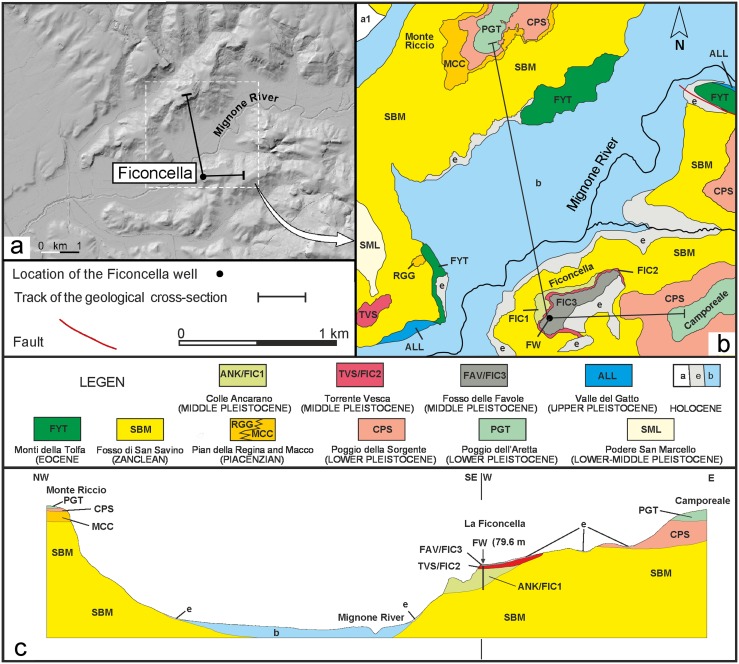
Fig 2. Digital elevation model of the Ficoncella site and geological sketch map of the study area.
a) Digital elevation model of the Ficoncella site area showing the flat terraced morphologies characterinzing the northern sector of the Latium coast; b) Detailed geological map of the study area and c) geological cross-section. The codes are those reported in the official geologic map of the Italian Geological Survey (sheet 354 Tarquinia). A modification occured in the sector of the Ficoncella site where the new data reported in this work have allowed us to better differentiate the stratigraphic units. On this basis the FIC1, FIC2, FIC3 units have been tentatively correlated to the units occurring in the official geological map. Legend: FYT – sandstone and mudstone turbidites; SBM – marine clay and silty clay with local intercalations of conglomerates; RGG/MCC – clayey sands and bioclastic calcarenites; CPS – bioclastic sands; PGT – fluvial gravel with carbonate and volcaniclastic clasts; SML – calcarenites and bioclastic sands; ANK/FIC1 – fluvial sands and silt rich in volcaniclastic sediments; TVS/FIC2 – Ignimbrite deposits; FAV/FIC3 – fluvio-lacustrine sandy silt deposits; ALL – fluvial sands and gravel rich in volcanic clasts; a1 – landslide deposits; e – eluvial and colluvial deposits; b – alluvial deposits.

