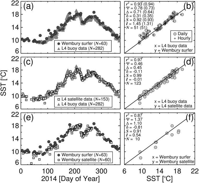
Fig 5. Sea surface temperature (SST) results from the study.
(a) Shows the time series of SST acquired by the surfer at Wembury beach overlain onto the daily median SST data from station L4 during the study period (N refers to the number of samples). (b) Shows a scatter plot of daily match-ups between SST acquired by the surfer at Wembury beach and SST data from station L4. Bracketed statistics refer to use of hourly match-ups between the two datasets. (c) Shows the time series of SST from satellite (AVHRR) at station L4 overlain onto the daily median SST data from station L4 (buoy) during the study period. (d) Shows a scatter plot of daily match-ups between SST from satellite (AVHRR) at station L4 and SST data from the buoy at station L4. (e) Shows the time series of SST from satellite (AVHRR) at Wembury beach overlain onto SST acquired by the surfer at Wembury beach during the study period. (f) Shows a scatter plot of daily match-ups between SST from satellite (AVHRR) at Wembury beach and SST data acquired by the surfer at Wembury beach. Statistics are denoted as follows: r 2 is the squared Pearson correlation coefficient; Ψ is the Root Mean Square Error; Δ is the unbiased Root Mean Square Error; δ is the bias; S and I are the slope and intercept of a linear regression respectively; and N refers to the number of match-ups.

