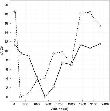
Fig. 2.

Relationship between ∆AICc values for models relating tail and crosswind components and their interaction to flight times over the ocean (open circles connected by hatched line) and along the coast (open squares connected by solid line) at different altitudes (m) for Savannah sparrows. Wind data is from the NCEP/NOAA dataset and was accessed through the Environmental-Data Automated Track Annotation Service provided by Movebank (32 x 32 km spatial and 3 h temporal resolution; Dodge et al. [29]). All wind conditions were interpolated over space and time using inverse distance weighting to the estimated spatial and temporal midpoint of a bird’s track over the ocean and along the coast
