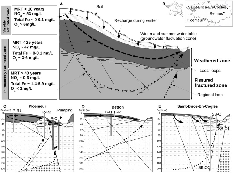
FIGURE 1.

Conceptual model of superficial and deep hydrogeologic flow paths or loops in a hard-rock aquifer and field-site characteristics. In (A), groundwater fluxes are mainly constrained by topographic relief, which creates hydraulic-pressure gradients. Transfers of O2- and NO3-rich recharge through the variably saturated zone of the weathered zone (solid vertical arrows) induce annual fluctuation of water table height. In the weathered zone, relatively short loops (represented by bold dashed arrows) have rapid water renewal resulting in short residence times, high O2 and NO3- concentrations, and low concentrations of total dissolved iron. Longer hydrologic loops (represented by dotted arrows) pass through the fissured fractured zone of the bedrock. Groundwater along these loops has much longer residence times with very low rates of renewal (a few percent annually) inducing hypoxic conditions, very low NO3- concentration, extended water-rock interaction, and elevated iron concentration. Part of a deep regional loop representing inter-watershed water transfer is depicted in panel (A). In (B), geographic location of the field-sites in the Brittany region is depicted. (C–E) show the main characteristics of each field-site: aquifer geometry, lithology, and configuration of wells and hydrogeologic loops. Lithology is represented by tilde signs (∼) for schist or plus signs (+) for granite. Abbreviations: MRT, mean residence-time of groundwater; P-R1, Ploemeur-Recent 1; P-R2, Ploemeur-Recent 2; P-O, Ploemeur-Old; B-O, Betton-Old; B-R, Betton-Recent; SB-O2, Saint-Brice-Old 2; SB-O, Saint-Brice-Old; SB-O1, Saint-Brice-Old 1.
