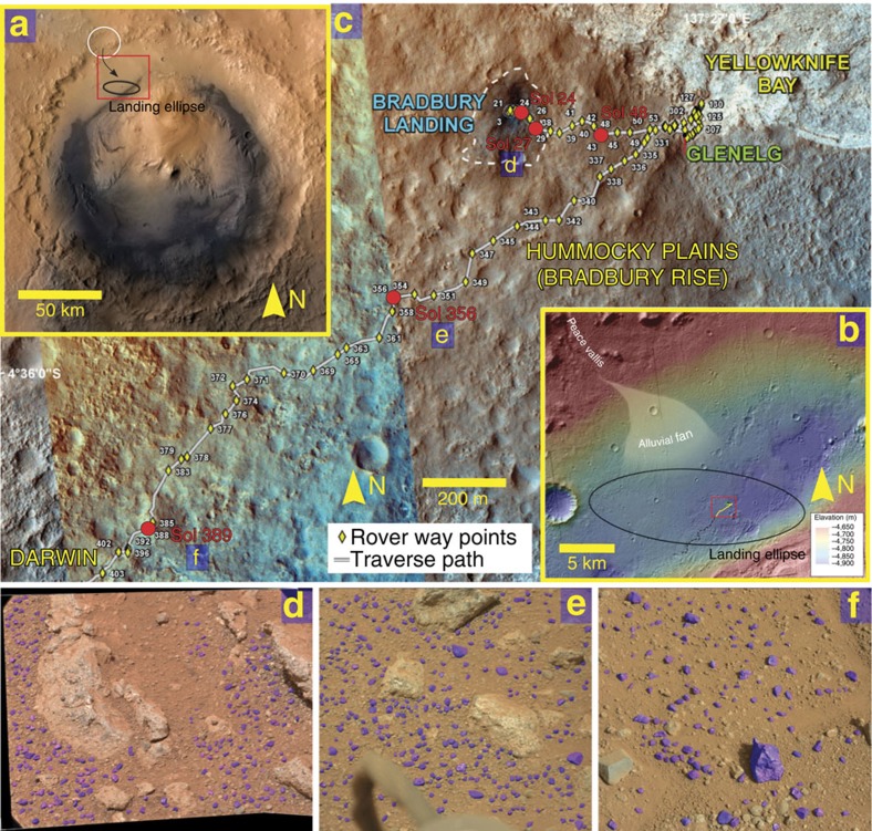
Figure 1. Mars field setting and the traverse of Curiosity.
(a) Gale Crater, with location of the Curiosity landing ellipse. White circle highlights eroded channel feeding the northern crater rim, which has been proposed to be the sediment source for Bradbury Rise conglomerates. Arrow indicates sediment transport direction, red box shows area in b. (b) The landing site (within the red box) and Curiosity's traverse for Sols (Martian days) 0–403 (yellow line) and Sols 403–817 (black dashed line). The Peace Vallis alluvial fan extends down dip and into Curiosity's landing ellipse. The landing ellipse also contains exhumed alluvial fan deposits that predate Peace Vallis, and define a bajada, which once depositionally infilled the crater margin5,6,7. Red box shows area in c. (c) Expanded view of Curiosity's traverse for Sols 0–403, with the locations of images studied in this paper (red dots). (d) Rounded pebbles at Sol 27, Link outcrop. Image number: CX00027MR0030530F399886415VA. (e) Rounded pebbles at Sol 356. Image number: 0356MR1452001000E1_DXXX. (f) Angular clasts at Sol 389. Image number: 0389ML1600090000E1_DXXX. On d–f, analysed grains are enhanced with purple colour. Image credits: (a) NASA/JPL-Caltech/ESA/DLR/FU Berlin/MSSS; (b,c) NASA/JPL-Caltech/Univ. of Arizona; (d–f) NASA/JPL-Caltech/MSSS.

