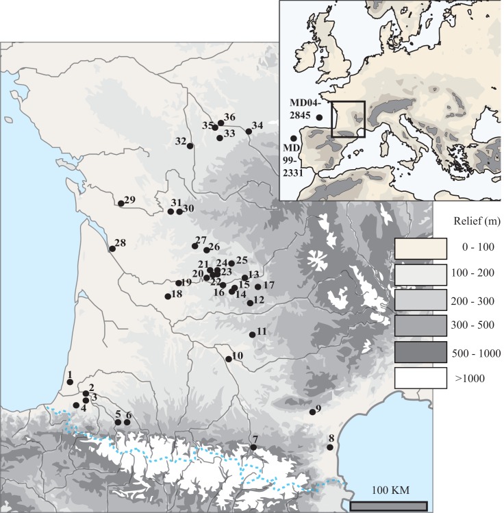
Fig 1. Geographic map with the location of the archeological sites used in this study along with the location of the deep-sea cores whose sedimentary record helped to establish the paleoclimatic correlations (MD04-2845 and MD99-2331).
Numbers identify the archeological sites as follows: 1-Dufaure. 2-Grotte Duruthy. 3-Bourrouilla. 4- Isturitz. 5-Espélugues. 6-Bois du Cantet. 7-La Vache. 8-Conques. 9-Abeurador. 10-Grotte du Salpêtre de Pompignan. 11-Abri Fontalès. 12-Peyrugues. 13-Peyrazet. 14-Roc de Combe. 15-Le Piage. 16-Combe Grenal. 17-Les Fieux. 18-Borie del Rey. 19-Le Flageolet 1 and 2. 20-Moulin du Roc. 21-La Ferrassie. 22-Abri Pataud. 23-Grotte Comarque. 24-Abri du Facteur. 25-Castanet. 26-Combe Saunière. 27-Pont d’Ambon. 28-Roc de Marcamps. 29-La Roche à Pierrot. 30-Montgaudier (Abri Pintaud-Gaudry). 31-Abri Ragout. 32-Bois Ragot. 33-Taillis-des-Coteaux. 34-Abri Garenne. 35-Les Cottés. 36-Abri Fritsch.

