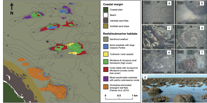
Figure 5. Habitat map of nearshore Halifax Bay, central Great Barrier Reef, Australia.
Habitat zones were delineated based on their relative benthic cover and coral community composition in ArcMap 10.2.2 (http://www.esri.com/). Bathymetric contours (at 0.5 m relative to lowest astronomical tide) are shown for topographic reference and were imported from Golden Surfer 12 (http://www.goldensoftware.com/). Ecological datasets for Paluma Shoals North and South were taken from Palmer et al.16. The final map was modified in Adobe Illustrator Version CS5 (http://www.adobe.com/). Representative images of habitat types are shown: (a) sand/mud seafloor; (b) sand-dominated substrates with massive Porites rus; (c) Turbinaria mesenterina “coral carpets”; (d) high coral cover reef crests with Montipora spp. and Acropora spp. framework; (e) rubble-dominated with low cover of Montipora spp. and Acropora spp.; (f) sand and rubble with patchy submassive corals (e.g. Lobophyllia sp., Galaxea sp., Goniopora sp.); (g) Goniastrea-dominated emergent reef flats.

