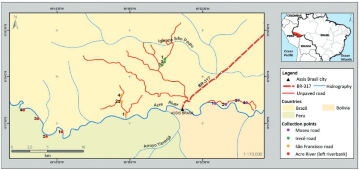
Fig. 1. : Map of Brazil highlighting the state of Acre, location of the district headquarters of Assis Brasil municipality and points of sandfly capture (legends 1, 2, 3 and 4). Irecê road: point 1 (10º53’40.55”S/ 69º36’2.53”W); point 2 (10º53’3.35”S/ 69º35’25.95”W); point 3 (10º52’46.11”S/ 69º35’12.81”W). São Francisco road: point 1 (10º56’49.5”S/ 69º38’17.4”W); point 2 (10º55’49.40”S/ 69º38’49.96”W); point 3 (10º55’52.4”S/ 69º38’38.6”W); point 4 (10º55’22.6”S/ 69º38’36.0”W). Museu road: point 1 (10º56’0,95”S/ 69º31’33,54”W); point 2 (10º56’4.49”S/ 69º30’45.71”W); point 3 (10º55’46.97”S/ 69º29’47.54”W); point 4 (10º55’58.30”S/ 69º29’11.07”W). Riparian Forest: point 1 (10º58’09.4”S/ 69º43’07.8”W); point 2 (10º56’4.49”S/ 69º30’45.71”W); point 3 (10º55’46.97”S/ 69º29’47.54”W); point 4 (10º55’58.30”S/ 69º29’11.07”W).

