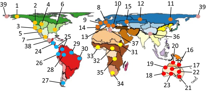
Fig. 3.
Continental comparative phylogeography hotspots or emerging hotspots (replicate studies using cumulatively increasing numbers of taxa) as inferred from scan of references database used here. Each set of colored dots represent a biogeographic region, except for those numbers that represent transition zones between regions: 36, OR-PA, Eastern Himalayas/Qunghai-Tibet Plateau; 37, ET-PA, Mediterranean Basin; 38, NT-NE, Middle America; 39, PA-NA, Beringea. All other localities identified as follows: 1, Alaska/East Beringea; 2, Pacific Northwest; 3, California; 4, Rocky Mountains; 5, Southwestern Aridlands; 6, Southeastern/Eastern; 7, Trans Mexican Volcanic Belt; 8, European Alps/Carpathians; 9, Western Palearctic; 10, Balkan Peninsula; 11, Eastern Asia; 12, Eurasia; 13, Italian Peninsula; 14, Iberian Peninsula; 15, Central Asia/Ponto-Caspian; 16, Australian Wet Tropics; 17, Interior Deserts; 18, Southwestern Australia; 19, Pilbara Region; 20, Monsoonal Tropics; 21, Souteastern Australia/Tallaganda; 22, Endorheic Basins; 23, Southern Australia; 24a, Lower Central American lowlands; 24b, Lower Central American highlands; 25, trans-Andean; 26, Andes; 27, Patagonia; 28, Amazon Rain Forest; 29, Caatinga/Cerrado; 30, Atlantic Rain Forest; 31, Eastern Arc (Afromontane) Mountains; 32, Central African Forest; 33, West African Forests/Savannas; 34, Cape Region; 35, Tropical African Forests/Savannas. Map modified with permission from ref. 4.

