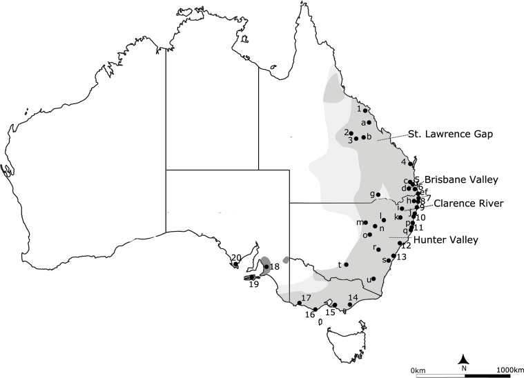
Fig 1. Geographical distribution of the koala, Phascolarctos cinereus, showing the sampling locations.
The current distribution is shown in grey, with the historical range in light grey and introduced populations in dark grey. Sampling locations are 1, Whitsunday/Mackay; 2, Blair Athol; 3, Clermont; 4, Maryborough; 5, Redlands; 6, Coomera; 7, Tyagarah; 8, Ballina; 9, Iluka; 10, Pine Creek; 11, Port Macquarie; 12, Maitland; 13, Campbelltown; 14, Strzelecki/East Gippsland; 15, French Island; 16, Cape Otway; 17, Bessiebelle; 18, Mt. Lofty Ranges; 19, Eyre Peninsula; 20, Kangaroo Island; a, Isaac Region; b, Peak Downs; c, Brookfield; d, Peak Crossing; e, Tweed Heads; f, Tanglewood; g, Balonne/Goondiwindi; h, Lismore; i, Glen Innes; j, Grafton; k, Armidale; l, Gunnedah; m, Coonamble; n, Coonabarabran; o Dubbo; p, Kempsey; q, Dunbogan; r, Bathurst; s, Mittagong; t, Narrandera; u, Bredbo. Sampling locations 1–20 contain at least 7 individuals, while sites a-u contain fewer individuals and/or individuals were widely dispersed over a large area. Putative biogeographic barriers Brisbane Valley and Clarence River, St. Lawrence Gap and Hunter Valley are shown as dashed lines.

