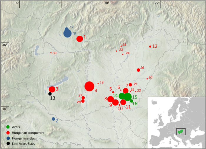
Figure 1. Location of investigated sites in the Carpathian Basin.

Sizes of circles indicate number of obtained mtDNA haplotypes from a certain site. Italic letters (17–30) mark previously published data12,13. Green color indicates Avar cemeteries, red color designates conqueror cemeteries, blue shows the contact zone, and black indicates 9th–10th century late Avar populations. The background map of the Carpathian Basin is owned by the IA RCH HAS, and was modified in Adobe Illustrator CS6 software. The map of Europe was downloaded from Wikipedia (https://commons.wikimedia.org/wiki/File%3ABlank_map_of_Europe.svg). Numbers of successfully typed individuals are in brackets after site names: 1. Levice-Géňa (9); 2. Zvonimirovo (4); 3. Balatonújlak-Erdődűlő (10); 4. Harta-Freifelt (16 + 1); 5. Baks-Iskola (3); 6. Szentes-Borbásföld (1); 7. Szentes-Derekegyháza (8); 8. Kiskundorozsma-Hosszúhát (9); 9. Szeged-Öthalom (8); 10. Kiszombor (2); 11. Makó-Igási járandó (8); 12. Nyíregyháza-Oross Megapark (2); 13. Vörs-Papkert (5); 14. Szegvár-Oromdűlő (8 Avars + 2 conquerors); 15. Székkutas-Kápolnadűlő (14); 16. Pitvaros-Víztározó (4); 17. Čakajovce (5); 18. Nitra-Šindolka (14); 19. Izsák-Balázspuszta (1); 20. Magyarhomorog (1); 21. Orosháza (1); 22. Szabadkígyós-Pálliget (1); 23. Aldebrő-Mocsáros (1); 24. Besenyőtelek-Szőrhát (1); 25. Eger-Szépasszonyvölgy (1); 26. Sárrétudvari-Hízóföld (4); 27. Fadd-Jegeshegy (5); 28. Mözs-Szárazdomb (3); 29. Örménykút (3); 30. Lébény-Kaszás (1).
