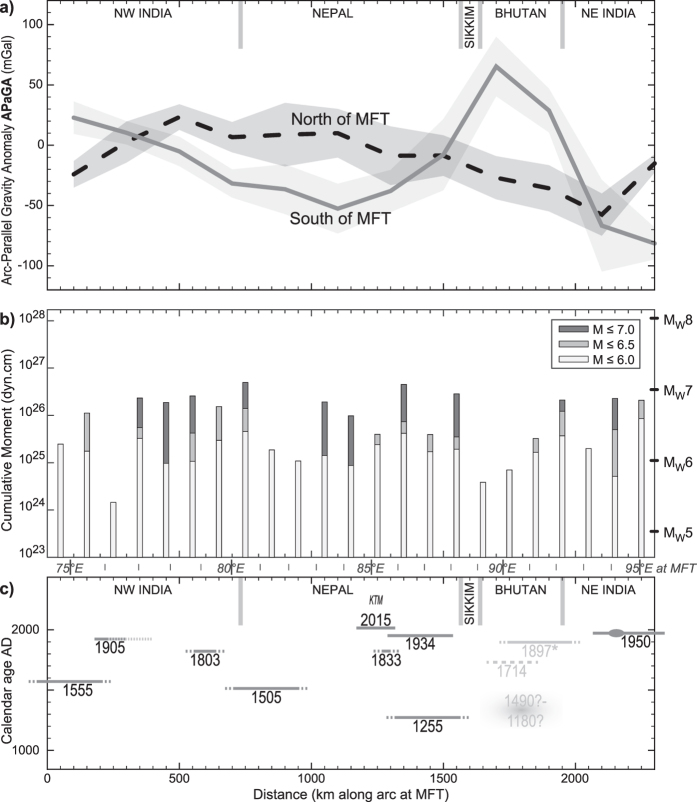
Figure 3. Variations of gravity and seismicity along the Himalayan arc.
Horizontal distance is measured along the arc approximation of the topographic front within the study area (see maps on other figures); reciprocally, longitudes at the arc approximating the topographic front are indicated between panels (b,c) as reference. (a) Arc-Parallel Gravity Anomaly (APaGA) on either side of the topographic front. Lines represent the averages to at least 25 km to the South, and between 25 and 145 km to the North; shaded areas represent the 1σ deviation of values within each 200-km long bin. Approximate country boundaries are indicated as reference. (b) Amount of energy released by moderate to strong (but neither major nor great) earthquakes. Cumulative moment is in dyn.cm, equivalent moment magnitude is shown on right axis. (c) Known major and great earthquakes in the Himalaya. Base figure is from ref. 29. Star notes that the 1897 earthquake occurred outside of the Himalaya, at the Shillong Plateau. The 1714 earthquake location is speculative. The medieval event in Bhutan is after refs 3 and 31. The 1905 Kangra earthquake rupture extent is from ref. 40, dotted line is reported from ref. 29. The epicentre was on the western end of the segment and rupture propagated eastwards (see Fig. 4). The knot on the 1950 Assam earthquake represents the 1947 M7.3 event. Other instrumentally recorded events on this diagram are the 1905 M7.9 Kangra earthquake, the 1934 M8.0 Bihar earthquakes, and the 2015 M7.8 and M7.3 events in the Kathmandu (KTM) region. Magnitudes as of the USGS catalogue (http://earthquake.usgs.gov/earthquakes/search/).

