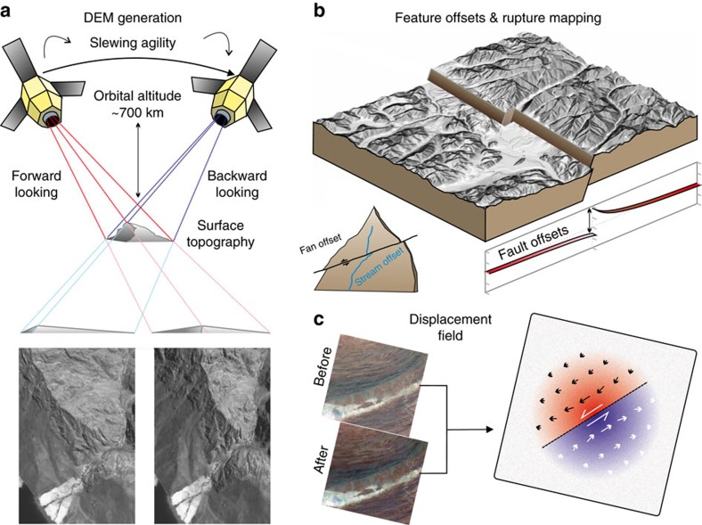
Figure 4. Derivation of DEMs from satellite optical data and examples of extraction of quantitative ground displacement data from the imagery and topography.
(a) Information on the Earth's topography is extracted from pairs of satellite images through the derivation of a DEM. This technique makes use of the stereoscopic effect achieved from imaging the ground from two distinct positions in orbit. Regions of relatively higher relief are shifted more between the two images, as shown in the example where the mountain ridge crest is displaced towards the edge of the backward-looking image and is more in the centre of the forward looking image. The latest satellite systems are very agile and are capable of taking multiple images along the same orbital track. This permits stereo and tri-stereo acquisitions such as with Pleaides 50 cm panchromatic imagery from which it is possible to derive a DEM of near light detection and ranging quality15. (b) Derived products based on the DEM can then be use to extract quantitative landscape and tectonic information. Hillshade and slope maps aid with interpretation of surface features, and pick out where fault ruptures reach the surface. By tracing the lateral shift in a fault surface trace from an earthquake break and combining this with the derived DEM it is possible to determine the changing fault dip along strike of a rupture120. Fault perpendicular profiles, as well as displaced features such as offset streams and alluvial fans, provide estimates of fault displacement and can be compared with slip models. They can also provide estimates of longer term fault slip rates if the offset features can be dated, as well as looking for characteristic earthquakes99. By differencing DEMs from before an earthquake with ones derived after, it is possible to determine the height change resulting from the coseismic deformation, highlighting the many active faults structures which may be involved in a rupture121. (c) The optical imagery itself can be used to estimate the horizontal displacement field using optical correlation techniques48,49 which are based on estimating the shift of features within the imagery due to motion of the ground. This can provide rapid estimates of a fault surface trace as well as the degree of off-fault deformation54. They can be combined with InSAR measurements to derive a three component displacement field and also used in fault slip modelling.

