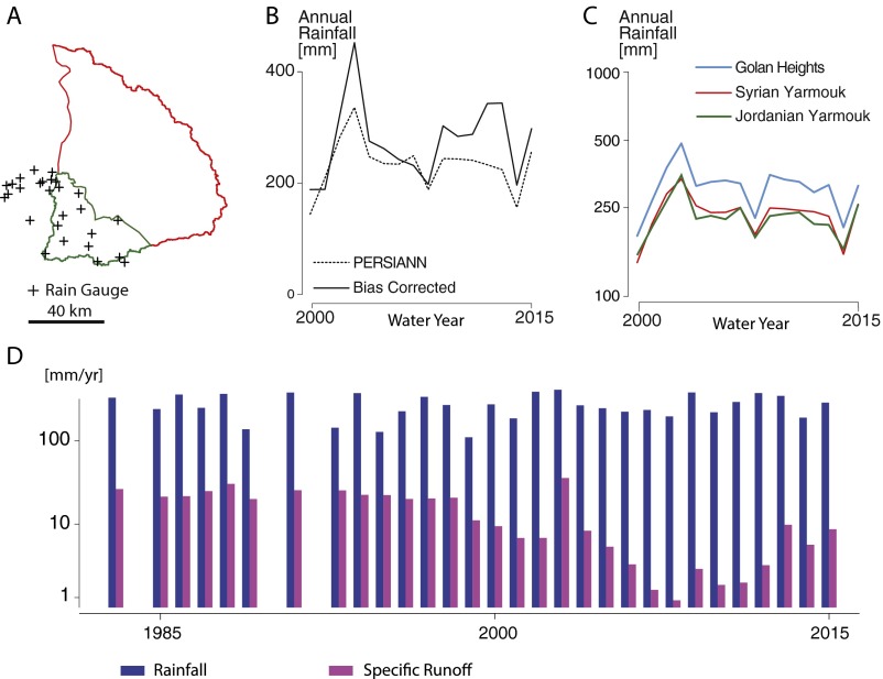
Fig. S1.
Rainfall. (A) Map of the Yarmouk basin with the location of the Jordanian rain gauges used to adjust remote sensing rainfall (n = 31). (B) Annual rainfall from the bias-corrected and original PERSIANN-CDR product (n = 16). (C) Bias-adjusted annual precipitation by region. Estimates, presented in log scale, show that despite differences in regional means, the trajectory (i.e., relative interannual change) of rainfall during the study period is comparable in Syria and in the two control regions (n = 16). (D) Annual rainfall and specific runoff volume over the 1983–2015 period (n = 30). Bias-corrected PERSIANN-CDR rainfall was spatially averaged over the Yarmouk basin, and specific runoff was computed by dividing the annual discharge volume (observed at the Maqarin/Al-Wehda gauge) by the surface area of the basin (6,138 km2). The effect of increasingly intensive irrigation water use in the upstream Syrian portion of the Yarmouk basin is visible in a downward trend in specific runoff (i.e., flow per unit area) starting in the mid-1990s, with no corresponding downward trend in precipitation. The downward stream flow trend reversed after 2011.

