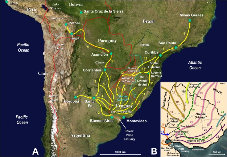
Fig 8. Livestock movement timeline in the early introduction and spread of Fasciola hepatica and lymnaeids in Uruguay.
Maps of South America (A) and Uruguay (B) showing main livestock passageways during the early Spanish and Portuguese colonizations. The analysis concerns the time of the old Viceroyalty of Rio de la Plata, from Buenos Aires in the South and the "Banda Oriental" in the Southeast up to "Alto Peru" in the North. 1, 14, First introductions of pigs in 1541, horses in 1574, and goats in 1577; 2, 15, 16, First and second introduction of cattle derived from Corrientes population in 1611 and 1617; 3, 17, Introduction of cattle from Misiones by Jesuits at the beginning of 17th century; 4, 5, 18, 19, First introduction of sheep from Santa Fe in 1727 (4, 18) and subsequent large scale cattle introductions with "faeneros" from Asuncion, Corrientes and Santa Fe (4, 5, 18, 19); 6, Livestock route for silver transport from Potosi mines from mid 16th century; 7, Original route for introduced goats in 1611–1618; 8, 20, Introduction of sheep by the Portuguese in 1734–1735; 9, 21, Largest rustle of more than 400,000 cattle in 1705, from Vaqueria del Mar to Vaqueria de los Pinares, at the southern part of the Jesuit Misiones Orientales area (brownish area); 10, 22, Livestock spread at mid and end of 17th century; 11, Livestock route (Camino Real, Ruta del Viamont or Caminho do Viamão) for gold transport from Minas Geraes mines from 1690; 12, Interconnection livestock route (Ruta de las Misiones or Caminho das Missões); 13, Interconnection livestock route (Ruta de la Vaquería or Caminho da Vacaria); 23, Groups of Portuguese "bandeirantes" also using livestock; 24, Northward spread of livestock. Background for A from composed satellite map of South America orthographic projection by NASA (full resolution of 1,215 x 1,712 pixels; public domain) via Wikimedia Commons. Original S. Mas-Coma.

